Home > Europe > United Kingdom > England > London > Towns > Park Langley
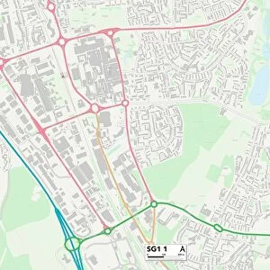
Stevenage SG1 1 Map

![]()
Wall Art and Photo Gifts from Map Marketing
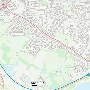
Stevenage SG1 1 Map
Postcode Sector Map of Stevenage SG1 1
Media ID 19981810
Abinger Close Badgers Close Denton Road East Close Eastgate Elder Way Exchange Road Farm Close Fox Road Garden Walk Great North Road Hillcrest Hillside Jennings Close Kings Road London Road Lyndale Market Square Mead Close Meadow Way Penn Road Ridgeway Rowland Road Southgate St Georges Way Stevenage The Dell The Hawthorns The Quadrant The Spur Towers Road West Close Westgate Crossgates Lindens Marshgate
FEATURES IN THESE COLLECTIONS
> Map Marketing
> Postcode Sector Maps
> SG - Stevenage
> Europe
> United Kingdom
> England
> London
> Related Images
> Europe
> United Kingdom
> England
> London
> Towns
> Copse Hill
> Europe
> United Kingdom
> England
> London
> Towns
> Grove Park
> Europe
> United Kingdom
> England
> London
> Towns
> North End
> Europe
> United Kingdom
> England
> London
> Towns
> Park Langley
> Europe
> United Kingdom
> England
> London
> Towns
> Southgate
> Europe
> United Kingdom
> England
> London
> Towns
> West Hill
> Maps and Charts
> Related Images
MADE IN AUSTRALIA
Safe Shipping with 30 Day Money Back Guarantee
FREE PERSONALISATION*
We are proud to offer a range of customisation features including Personalised Captions, Color Filters and Picture Zoom Tools
SECURE PAYMENTS
We happily accept a wide range of payment options so you can pay for the things you need in the way that is most convenient for you
* Options may vary by product and licensing agreement. Zoomed Pictures can be adjusted in the Cart.