Home > Maps and Charts > Related Images
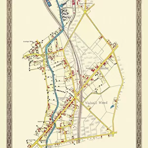
Old Map of the Village of Aldridge in Staffordshire1884

![]()
Wall Art and Photo Gifts from MapSeeker
Old Map of the Village of Aldridge in Staffordshire1884
PL001
Welcome to the Mapseeker Image library and enter an historic gateway to one of the largest on-line collections of Historic Maps, Nostalgic Views, Vista's and Panorama's from a World gone by.
Media ID 20346927
Historic Map Old Town Plan Town Plan Aldridge
FEATURES IN THESE COLLECTIONS
> MapSeeker
> British Town And City Plans
> English & Welsh PORTFOLIO
> Maps and Charts
> Related Images
EDITORS COMMENTS
This print takes us back in time to the quaint village of Aldridge in Staffordshire, as it stood proudly in 1884. The old map of Aldridge, meticulously preserved and beautifully presented, offers a glimpse into the rich history and heritage of this charming English settlement. The intricate details on this historic town plan reveal the layout of streets, buildings, and landmarks that once defined the village. Every corner is marked with precision, allowing us to trace our fingers along its paths and imagine life as it was over a century ago. Aldridge village emerges from this old map like a hidden treasure waiting to be discovered. Its winding roads lead us through clusters of cottages adorned with thatched roofs and chimneys billowing smoke. We can almost hear the distant sounds of horse-drawn carriages traversing its cobblestone streets. As we study this fascinating piece of history, we are reminded that every street has witnessed countless stories unfold – tales of love, laughter, triumphs, and hardships. It serves as a reminder that behind every name etched onto these faded lines lies an entire community's collective memories. Whether you have personal ties to Aldridge or simply appreciate delving into the past through cartography, this old map print is sure to evoke nostalgia and curiosity within you. Let it transport you back in time as you explore the enchanting Village of Aldridge through its storied past captured on paper.
MADE IN AUSTRALIA
Safe Shipping with 30 Day Money Back Guarantee
FREE PERSONALISATION*
We are proud to offer a range of customisation features including Personalised Captions, Color Filters and Picture Zoom Tools
SECURE PAYMENTS
We happily accept a wide range of payment options so you can pay for the things you need in the way that is most convenient for you
* Options may vary by product and licensing agreement. Zoomed Pictures can be adjusted in the Cart.