Home > Arts > Artists > T > John Tallis
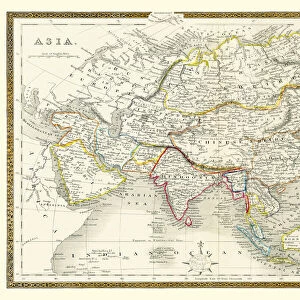
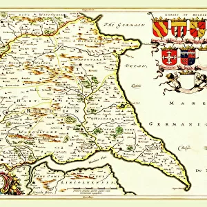
Cabool, The Punjab and Beloochistan 1851

![]()
Wall Art and Photo Gifts from MapSeeker
Cabool, The Punjab and Beloochistan 1851
A fine facimile artworked from an antique original map of Cabool, The Punjab and Beloochistan, issued as part of the 1851 edition of John Tallis and Companys " The Illustrated Atlas and Modern History of the World"
Welcome to the Mapseeker Image library and enter an historic gateway to one of the largest on-line collections of Historic Maps, Nostalgic Views, Vista's and Panorama's from a World gone by.
Media ID 20347412
© Mapseeker Publishing Ltd
John Tallis John Tallis Map Tallis Map Punjab
FEATURES IN THESE COLLECTIONS
> MapSeeker
> Maps of Asia and Middle East
> Maps of Countries in Asia PORTFOLIO
> Arts
> Artists
> T
> John Tallis
> Maps and Charts
> Related Images
> Maps and Charts
> World
EDITORS COMMENTS
This print showcases a remarkable piece of history - a fine facsimile artworked from an antique original map of Cabool, The Punjab, and Beloochistan. This exquisite map was originally issued as part of the 1851 edition of John Tallis and Company's "The Illustrated Atlas and Modern History of the World". Transporting us back to the mid-19th century, this old map provides a fascinating glimpse into the geographical landscape and political boundaries that once defined this region. With intricate details meticulously captured by John Tallis and his talented collaborator John Rapkin, every corner of Cabool, The Punjab, and Beloochistan is brought to life. As we explore this vintage treasure, we are immersed in a world where cartography meets artistry. The delicate lines trace rivers meandering through vast plains while mountain ranges majestically rise on the horizon. Towns and cities are marked with tiny symbols denoting their significance in trade or governance. Beyond its aesthetic appeal lies historical significance. This map serves as a testament to the exploration endeavors undertaken during that era when knowledge about distant lands was still being discovered. It reminds us how maps were not just navigational tools but also works of art that celebrated human curiosity. Preserved through time with utmost care, this print allows us to appreciate both the craftsmanship involved in creating such masterpieces as well as our collective journey towards understanding our world better.
MADE IN AUSTRALIA
Safe Shipping with 30 Day Money Back Guarantee
FREE PERSONALISATION*
We are proud to offer a range of customisation features including Personalised Captions, Color Filters and Picture Zoom Tools
SECURE PAYMENTS
We happily accept a wide range of payment options so you can pay for the things you need in the way that is most convenient for you
* Options may vary by product and licensing agreement. Zoomed Pictures can be adjusted in the Cart.