Home > Europe > United Kingdom > England > Staffordshire > Cannock
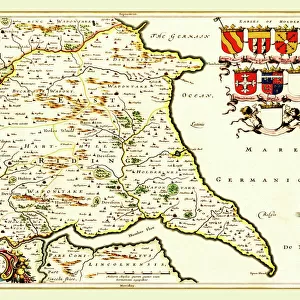
Old Map of Cannock Town in Staffordshire 1886

![]()
Wall Art and Photo Gifts from MapSeeker
Old Map of Cannock Town in Staffordshire 1886
PL004
Welcome to the Mapseeker Image library and enter an historic gateway to one of the largest on-line collections of Historic Maps, Nostalgic Views, Vista's and Panorama's from a World gone by.
Media ID 20346921
Historic Map Old Town Plan Town Plan Cannock
FEATURES IN THESE COLLECTIONS
> MapSeeker
> British Town And City Plans
> English & Welsh PORTFOLIO
> Europe
> United Kingdom
> England
> Staffordshire
> Cannock
> Europe
> United Kingdom
> England
> Staffordshire
> Related Images
> Maps and Charts
> Related Images
EDITORS COMMENTS
This print showcases the "Old Map of Cannock Town in Staffordshire 1886 (PL004)" from MapSeeker. Stepping back in time, this historic map offers a fascinating glimpse into the past, allowing us to explore the intricate details and layout of Cannock town as it stood over a century ago. The carefully preserved lines and markings on this old map provide an invaluable resource for history enthusiasts, researchers, or anyone with a deep connection to Cannock. With its comprehensive depiction of streets, landmarks, and even individual buildings, this piece serves as an essential tool for understanding how the town has evolved throughout time. Immerse yourself in the rich heritage of Cannock as you trace your finger along its winding roads and discover forgotten corners that have since transformed. From bustling market squares to quaint residential areas, every inch of this meticulously crafted plan tells a story waiting to be unraveled. Whether you are seeking inspiration for architectural projects or simply yearning to connect with your roots, this remarkable print holds immense value. It is not just an old map; it is a gateway into another era – one where horse-drawn carriages roamed these very streets and communities thrived amidst their surroundings. Appreciate the artistry behind cartography while exploring local history with this extraordinary photograph from MapSeeker. Let it transport you through time and ignite your imagination as you delve into the enchanting world of historic maps - specifically capturing Cannock's unique charm in 1886.
MADE IN AUSTRALIA
Safe Shipping with 30 Day Money Back Guarantee
FREE PERSONALISATION*
We are proud to offer a range of customisation features including Personalised Captions, Color Filters and Picture Zoom Tools
SECURE PAYMENTS
We happily accept a wide range of payment options so you can pay for the things you need in the way that is most convenient for you
* Options may vary by product and licensing agreement. Zoomed Pictures can be adjusted in the Cart.