Home > Popular Themes > Railway Posters
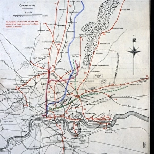
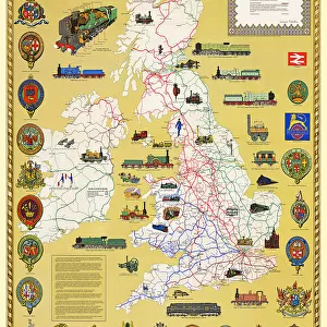
Old Map of the Great Eastern Railway 1887

![]()
Wall Art and Photo Gifts from MapSeeker
Old Map of the Great Eastern Railway 1887
RW0030
Welcome to the Mapseeker Image library and enter an historic gateway to one of the largest on-line collections of Historic Maps, Nostalgic Views, Vista's and Panorama's from a World gone by.
Media ID 20347227
© Mapseeker Publishing Ltd
Historic Railway Map Old Railway Map Railway Map Great Eastern Railway
FEATURES IN THESE COLLECTIONS
> Maps and Charts
> Related Images
> MapSeeker
> Old Railway and Canal Map Collection
> Old Railway Maps PORTFOLIO
> Popular Themes
> Railway Posters
EDITORS COMMENTS
This print showcases an exquisite piece of history, the "Old Map of the Great Eastern Railway 1887". Stepping back in time to the late 19th century, this remarkable railway map offers a glimpse into the intricate web of tracks and stations that once connected bustling cities and picturesque countryside. With its delicate details and vintage charm, it serves as a testament to the ingenuity and ambition of early railway engineers. The map's rich hues transport us to an era when steam locomotives ruled the rails, their rhythmic chugging echoing through vast landscapes. Every line on this meticulously crafted cartographic masterpiece represents a journey taken or yet to be embarked upon. It invites us to explore forgotten routes, envisioning ourselves aboard one of those majestic trains bound for distant destinations. As we study this historic relic, our imagination runs wild with stories from bygone days: passengers eagerly awaiting departures at ornate Victorian stations; goods being transported across counties; families reuniting after long separations. The Great Eastern Railway map is not just an artifact but also a portal into an era defined by progress and adventure. Whether you are a history enthusiast or simply captivated by antique maps, this print is sure to ignite your curiosity about our transportation heritage. Display it proudly in your home or office space as a reminder that beneath our modern infrastructure lies a fascinating tapestry woven with iron tracks connecting hearts and minds across time.
MADE IN AUSTRALIA
Safe Shipping with 30 Day Money Back Guarantee
FREE PERSONALISATION*
We are proud to offer a range of customisation features including Personalised Captions, Color Filters and Picture Zoom Tools
SECURE PAYMENTS
We happily accept a wide range of payment options so you can pay for the things you need in the way that is most convenient for you
* Options may vary by product and licensing agreement. Zoomed Pictures can be adjusted in the Cart.