Home > Europe > United Kingdom > England > Yorkshire > Bentley
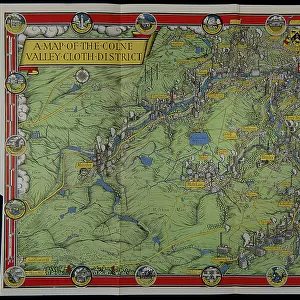
A map of the Colne Valley Cloth District

Wall Art and Photo Gifts from Mary Evans Picture Library
A map of the Colne Valley Cloth District
Pictorial map of the Colne Valley Cloth District in Yorkshire, drawn by the poster artist and designer Leslie MacDonald Gill the year before his death, in 1946. This unusual industrial map depicts prominent sites associated with textile production in the region and includes the crests of Huddersfield and Holmfirth together with prominent local landmarks. It was originally included as a foldout map in the publication Colne Valley Cloth, From Earliest Times to Present Day by Phyllis Bentley (1947). Date: 1946
Mary Evans Picture Library makes available wonderful images created for people to enjoy over the centuries
Media ID 32254488
© The Twentieth Century Posters Collection / Mary Evans
1946 1947 Bentley Cloth Colne Crests Depicts Designer Drawn Earliest Export Foldout Gill Holmfirth Huddersfield Included Includes Landmarks Leslie Macdonald Originally Phyllis Pictorial Present Prominent Publication Publisher Region Sites Textile Times Unusual Wollen Year
FEATURES IN THESE COLLECTIONS
> Arts
> Artists
> P
> those present
> Europe
> United Kingdom
> England
> Yorkshire
> Bentley
> Europe
> United Kingdom
> England
> Yorkshire
> Holmfirth
> Europe
> United Kingdom
> England
> Yorkshire
> Huddersfield
> Historic
> Monuments and landmarks
> Historical sites
> Historic
> Monuments and landmarks
> Mary Evans Prints Online
> New Images July 2023
EDITORS COMMENTS
This map print, titled 'Colne Valley Cloth District,' dates back to 1946 and was created by the renowned British poster artist and designer, Leslie MacDonald Gill, in the year before his death. The map offers a unique and intriguing perspective on the industrial history of the Colne Valley Cloth District in Yorkshire, England. The map is a pictorial representation of the region's prominent sites associated with textile production, making it an unusual and fascinating piece for historians, textile enthusiasts, and art collectors. The map includes the crests of Huddersfield and Holmfirth, two significant towns in the district, as well as other local landmarks. Originally included as a foldout map in Phyllis Bentley's publication, 'Colne Valley Cloth, From Earliest Times to Present Day,' published in 1947, this map provides a visual representation of the area's rich textile heritage. The map highlights the importance of the district in the woolen export industry, showcasing the group of mills and factories that were once a significant part of the region's economic and industrial landscape. Leslie MacDonald Gill's artistic talent is evident in the intricate details of the map, which captures the essence of the Colne Valley Cloth District's industrial past. The map's unique design and historical significance make it a valuable addition to any collection, offering a glimpse into the region's textile history and the artistic vision of one of Britain's most celebrated poster artists.
MADE IN AUSTRALIA
Safe Shipping with 30 Day Money Back Guarantee
FREE PERSONALISATION*
We are proud to offer a range of customisation features including Personalised Captions, Color Filters and Picture Zoom Tools
SECURE PAYMENTS
We happily accept a wide range of payment options so you can pay for the things you need in the way that is most convenient for you
* Options may vary by product and licensing agreement. Zoomed Pictures can be adjusted in the Cart.