Metal Print > Europe > Norway > Maps
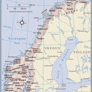
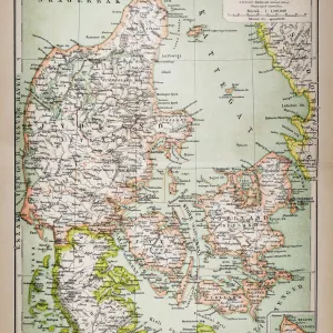
Metal Print : Map of Scandinavia 1862


![]()
Metal Prints From Fine Art Finder
Map of Scandinavia 1862
JAB5037349 Map of Scandinavia 1862; (add.info.: Map of Scandinavia 1862); Photo ©Jaime Abecasis
Media ID 38277238
© ©Jaime Abecasis / Bridgeman Images
Abecasis Danish Danish Women Denmark Nordic Countries Norvege Norway Norway Norwegian Norwegian Norwegians Suede Sverige Sweden Geographical Map
10"x8" (25x20cm) Table Top Metal Print
Elevate your space with the stunning 'Map of Scandinavia 1862' metal print from Media Storehouse! This unique piece, crafted by Jaime Abecasis and sourced from Fine Art Finder, brings a touch of vintage charm to any room. The intricate details and rich colors are perfectly captured on high-quality aluminum for a truly eye-catching display.
Table Top Metal Prints feature rounded corners and an easel back for easy display. Available in two sizes, 18x13cm (7x5) or 25x20cm (10x8). Lightweight and vibrant, they are perfect for displaying artwork and are guaranteed to add style to any desk or table top. The unique material is fade, moisture, chemical and scratch resistant to help ensure this art lasts a lifetime.
Made with durable metal and luxurious printing techniques, metal prints bring images to life and add a modern touch to any space
Estimated Product Size is 20.3cm x 25.4cm (8" x 10")
These are individually made so all sizes are approximate
Artwork printed orientated as per the preview above, with landscape (horizontal) or portrait (vertical) orientation to match the source image.
FEATURES IN THESE COLLECTIONS
> Europe
> Denmark
> Related Images
> Europe
> Norway
> Related Images
> Europe
> Sweden
> Related Images
EDITORS COMMENTS
This stunning print captures a Map of Scandinavia from the year 1862, showcasing the intricate details of the Nordic countries during the 19th century. The map provides a glimpse into the geographical layout of Denmark, Norway, and Sweden, highlighting their unique landscapes and borders.
The engraving depicts the rich history and cultural heritage of these European nations, offering a visual representation of their interconnectedness and shared heritage. From the fjords of Norway to the forests of Sweden, each region is meticulously illustrated with precision and accuracy.
As we gaze upon this historical artifact, we are transported back in time to an era marked by exploration and discovery. The Map of Scandinavia serves as a reminder of how far we have come in terms of understanding our world and its diverse inhabitants.
Through Jaime Abecasis' lens, this piece becomes more than just a map - it becomes a work of art that celebrates the beauty and complexity of Scandinavian geography. It is a testament to human ingenuity and curiosity, capturing a moment in history when cartography was at its peak.
Let us marvel at this Map of Scandinavia from 1862 as we appreciate its significance in shaping our understanding of Europe's northernmost lands.
MADE IN AUSTRALIA
Safe Shipping with 30 Day Money Back Guarantee
FREE PERSONALISATION*
We are proud to offer a range of customisation features including Personalised Captions, Color Filters and Picture Zoom Tools
SECURE PAYMENTS
We happily accept a wide range of payment options so you can pay for the things you need in the way that is most convenient for you
* Options may vary by product and licensing agreement. Zoomed Pictures can be adjusted in the Basket.