Metal Print > Arts > Artists > B > Joan Blaeu
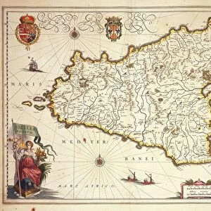
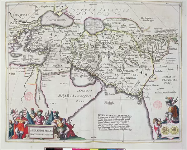
Metal Print : Map of the travels of Alexander the Great (356-323 BC) from Le Theatre du Monde
 from Le Theatre du Monde")


![]()
Metal Prints from Fine Art Finder
Map of the travels of Alexander the Great (356-323 BC) from Le Theatre du Monde
BMR165845 Map of the travels of Alexander the Great (356-323 BC) from Le Theatre du Monde or Nouvel Atlas, 1645 (coloured engraving) by Blaeu, Willem (1571-1638) and Joan (1596-1673); Bibliotheque Mazarine, Paris, France; (add.info.: Carte des voyages d Alexandre le Grand; ); eBibliotheque Mazarine; eArchives Charmet; Dutch, out of copyright
Media ID 22351456
© Bibliotheque Mazarine Archives Charmet / Bridgeman Images
Arabia Cartographic Conquest Guillaume Gulf Jean Bleau
10"x8" (25x20cm) Table Top Metal Print
Step back in time and explore the legendary conquests of Alexander the Great with our stunning Metal Prints featuring the intricately detailed Map of the Travels of Alexander the Great. This captivating engraving, hailing from Le Theatre du Monde by Bridgeman Images, transports you to the ancient world as you follow the epic journey of one of history's most iconic figures. The vibrant colors and textures of the Metal Print bring this historic map to life, making it a mesmerizing addition to any home or office space. Elevate your decor and ignite your imagination with this timeless piece of art.
Table Top Metal Prints feature rounded corners and an easel back for easy display. Available in two sizes, 18x13cm (7x5) or 25x20cm (10x8). Lightweight and vibrant, they are perfect for displaying artwork and are guaranteed to add style to any desk or table top. The unique material is fade, moisture, chemical and scratch resistant to help ensure this art lasts a lifetime.
Made with durable metal and luxurious printing techniques, metal prints bring images to life and add a modern touch to any space
Estimated Product Size is 25.4cm x 20.3cm (10" x 8")
These are individually made so all sizes are approximate
Artwork printed orientated as per the preview above, with landscape (horizontal) or portrait (vertical) orientation to match the source image.
FEATURES IN THESE COLLECTIONS
> Fine Art Finder
> Artists
> German School
> Fine Art Finder
> Artists
> Willem and Joan (1596-1673) Blaeu
> Fine Art Finder
> Maps (celestial & Terrestrial)
> Arts
> Artists
> B
> Joan Blaeu
> Arts
> Artists
> B
> Willem Blaeu
> Europe
> France
> Paris
> Maps
> Europe
> France
> Paris
> Related Images
> Maps and Charts
> Related Images
EDITORS COMMENTS
This print showcases the intricate "Map of the travels of Alexander the Great" from Le Theatre du Monde or Nouvel Atlas, created in 1645 by renowned cartographers Willem and Joan Blaeu. The map, a colored engraving, is currently housed at Bibliotheque Mazarine in Paris, France. With its rich historical significance, this map offers a glimpse into the remarkable conquests and expeditions undertaken by one of history's most legendary figures - Alexander the Great. Spanning from 356 to 323 BC, these journeys shaped not only his empire but also influenced future civilizations across Europe, Asia Minor, and beyond. The detailed cartographic representation highlights various regions such as the Middle East and Arabia where Alexander left an indelible mark through his military campaigns. It vividly portrays his strategic movements as he navigated through vast territories including present-day Iran, Egypt, India, and Greece. As we delve into this mesmerizing artwork captured by Bridgeman Images' lens for Fine Art Finder's collection, we are transported back in time to witness the grandeur of ancient empires colliding on this very map. Its masterful craftsmanship invites us to explore each contour line with awe-inspiring curiosity while tracing Alexander's footsteps across rivers like Jean Bleau Gulf. This extraordinary piece serves as both a testament to human ambition and an ode to cartographic excellence. It reminds us that even centuries later; our fascination with history continues unabated as we marvel at maps
MADE IN AUSTRALIA
Safe Shipping with 30 Day Money Back Guarantee
FREE PERSONALISATION*
We are proud to offer a range of customisation features including Personalised Captions, Color Filters and Picture Zoom Tools
SECURE PAYMENTS
We happily accept a wide range of payment options so you can pay for the things you need in the way that is most convenient for you
* Options may vary by product and licensing agreement. Zoomed Pictures can be adjusted in the Cart.