Metal Print > Fine Art Finder > Artists > Hermann Moll
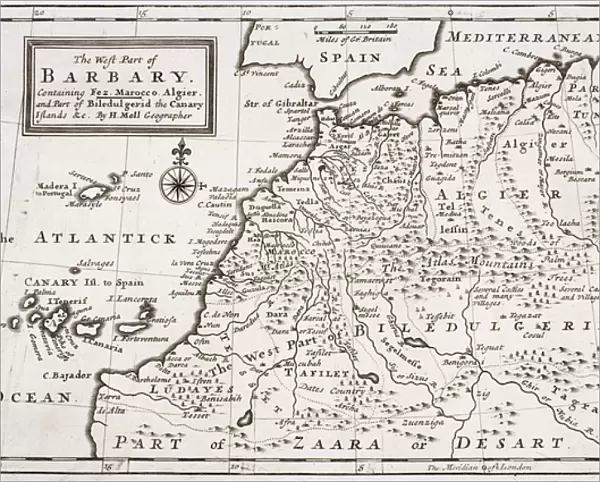
Metal Print : Map of The West Part of Barbary, c. 1720 (litho)
")


Please select a smaller print size for this image
![]()
Metal Prints from Fine Art Finder
Map of The West Part of Barbary, c. 1720 (litho)
KW276200 Map of The West Part of Barbary, c.1720 (litho) by Moll, Hermann (fl.1678-1732); Private Collection; (add.info.: Containing Fez, Marocco, Algier and Part of Biledulgerid, The Canary Islands ; ); Ken Welsh; German, out of copyright
Media ID 12785635
© www.bridgemanimages.com
Algeria Mediterranean Morocco Sahara Desert Tunis Tunisia
10"x8" (25x20cm) Table Top Metal Print
Discover the rich history of the Barbary Coast with our stunning Metal Print of 'Map of The West Part of Barbary, c.1720' by Hermann Moll. This intricately detailed lithograph, sourced from Bridgeman Images through Fine Art Finder, showcases the western region of Barbary, including Fez, Marocco, Algier, and part of Biledulgerid. The metallic finish adds depth and dimension to the map, making it a captivating addition to any room. Transport yourself back in time and adorn your walls with this beautiful piece of historical cartography.
Table Top Metal Prints feature rounded corners and an easel back for easy display. Available in two sizes, 18x13cm (7x5) or 25x20cm (10x8). Lightweight and vibrant, they are perfect for displaying artwork and are guaranteed to add style to any desk or table top. The unique material is fade, moisture, chemical and scratch resistant to help ensure this art lasts a lifetime.
Made with durable metal and luxurious printing techniques, metal prints bring images to life and add a modern touch to any space
Estimated Product Size is 25.4cm x 20.3cm (10" x 8")
These are individually made so all sizes are approximate
Artwork printed orientated as per the preview above, with landscape (horizontal) or portrait (vertical) orientation to match the source image.
EDITORS COMMENTS
This lithograph, titled "Map of The West Part of Barbary, c. 1720" takes us on a visual journey through the rich and diverse landscapes of North Africa. Created by the renowned cartographer Hermann Moll, this print showcases his meticulous attention to detail and geographical accuracy. The map encompasses an expansive region that includes Fez, Morocco, Algiers, and parts of Biledulgerid. It also extends its reach to encompass the enchanting Canary Islands in the Atlantic Ocean. As we explore this ancient land through Moll's eyes, we are transported back in time to a period when these territories were at their height. The vibrant colors used in this lithograph bring life to every corner of the map - from the golden sands of Zaara Desert to the vast expanse of Sahara Desert. These natural wonders serve as a reminder of both the harshness and beauty found within these arid lands. As our gaze travels across this piece, we can't help but be captivated by its historical significance. This map provides invaluable insight into not only North African geography but also European exploration during that era. With each glance at this stunning print, one cannot help but feel a sense of wonderment for all that lies within its borders - from bustling cities to remote oases nestled amidst endless dunes. It serves as a testament to mankind's eternal quest for knowledge and discovery.
MADE IN AUSTRALIA
Safe Shipping with 30 Day Money Back Guarantee
FREE PERSONALISATION*
We are proud to offer a range of customisation features including Personalised Captions, Color Filters and Picture Zoom Tools
SECURE PAYMENTS
We happily accept a wide range of payment options so you can pay for the things you need in the way that is most convenient for you
* Options may vary by product and licensing agreement. Zoomed Pictures can be adjusted in the Cart.