Poster Print > Fine Art Finder > Artists > Hermann Moll
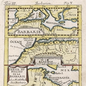
Poster Print : Map of The West Part of Barbary, c. 1720 (litho)
")


Please select a smaller print size for this image
![]()
Poster Prints from Fine Art Finder
Map of The West Part of Barbary, c. 1720 (litho)
KW276200 Map of The West Part of Barbary, c.1720 (litho) by Moll, Hermann (fl.1678-1732); Private Collection; (add.info.: Containing Fez, Marocco, Algier and Part of Biledulgerid, The Canary Islands ; ); Ken Welsh; German, out of copyright
Media ID 12785635
© www.bridgemanimages.com
Algeria Mediterranean Morocco Sahara Desert Tunis Tunisia
A4 (29.7 x 21cm) Poster Print
Discover the rich history of the Barbary Coast with our stunning poster print from Media Storehouse. This intriguing map, titled "Map of The West Part of Barbary, c.1720 (litho)" by Hermann Moll, offers a captivating glimpse into the region as it was known over 300 years ago. Featuring detailed depictions of Fez, Marocco, Algier, and part of Biledulgerid, this vintage map is a must-have for history enthusiasts, cartographers, or anyone with a passion for the past. Bring the stories of this fascinating part of the world into your home or office with this beautiful and authentic reproduction from Bridgeman Images through Fine Art Finder.
Premium quality poster prints are printed on luxurious semi-gloss satin 270 gsm paper. Our meticulously crafted poster prints offer an affordable option for decorating any space, making them ideal for living rooms, bedrooms, offices and beyond. To ensure your poster arrives in good condition, we roll and send them in strong mailing tubes.
Poster prints are budget friendly enlarged prints in standard poster paper sizes (A0, A1, A2, A3 etc). Whilst poster paper is sometimes thinner and less durable than our other paper types, they are still ok for framing and should last many years. Our Archival Quality Photo Prints and Fine Art Paper Prints are printed on higher quality paper and the choice of which largely depends on your budget.
Estimated Product Size is 30.3cm x 21.6cm (11.9" x 8.5")
These are individually made so all sizes are approximate
Artwork printed orientated as per the preview above, with landscape (horizontal) or portrait (vertical) orientation to match the source image.
EDITORS COMMENTS
This lithograph, titled "Map of The West Part of Barbary, c. 1720" takes us on a visual journey through the rich and diverse landscapes of North Africa. Created by the renowned cartographer Hermann Moll, this print showcases his meticulous attention to detail and geographical accuracy. The map encompasses an expansive region that includes Fez, Morocco, Algiers, and parts of Biledulgerid. It also extends its reach to encompass the enchanting Canary Islands in the Atlantic Ocean. As we explore this ancient land through Moll's eyes, we are transported back in time to a period when these territories were at their height. The vibrant colors used in this lithograph bring life to every corner of the map - from the golden sands of Zaara Desert to the vast expanse of Sahara Desert. These natural wonders serve as a reminder of both the harshness and beauty found within these arid lands. As our gaze travels across this piece, we can't help but be captivated by its historical significance. This map provides invaluable insight into not only North African geography but also European exploration during that era. With each glance at this stunning print, one cannot help but feel a sense of wonderment for all that lies within its borders - from bustling cities to remote oases nestled amidst endless dunes. It serves as a testament to mankind's eternal quest for knowledge and discovery.
MADE IN AUSTRALIA
Safe Shipping with 30 Day Money Back Guarantee
FREE PERSONALISATION*
We are proud to offer a range of customisation features including Personalised Captions, Color Filters and Picture Zoom Tools
SECURE PAYMENTS
We happily accept a wide range of payment options so you can pay for the things you need in the way that is most convenient for you
* Options may vary by product and licensing agreement. Zoomed Pictures can be adjusted in the Cart.