Metal Print > Maps and Charts > British Empire Maps
Metal Print : British Empire throughout the World (coloured engraving)
")


![]()
Metal Prints from Fine Art Finder
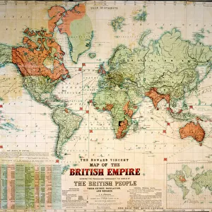
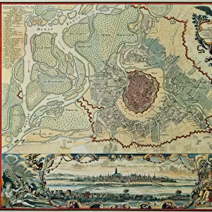
British Empire throughout the World (coloured engraving)
XCF275033 British Empire throughout the World (coloured engraving) by English School, (19th century); Private Collection; English, out of copyright
Media ID 12790621
© www.bridgemanimages.com
Cartouche Colonies Colonisation Geographical Globalisation Imperialism Mapping Georgraphy
10"x8" (25x20cm) Table Top Metal Print
Step back in time and explore the grandeur of the British Empire with our stunning Metal Prints from Media Storehouse, featuring the captivating coloured engraving "British Empire throughout the World" by the English School from Bridgeman Images. This intricately detailed 19th-century work of art, now available as a Metal Print, showcases the vast reach and influence of the British Empire in vibrant colours. Add a touch of history and elegance to your home or office with this unique and timeless piece from Fine Art Finder.
Table Top Metal Prints feature rounded corners and an easel back for easy display. Available in two sizes, 18x13cm (7x5) or 25x20cm (10x8). Lightweight and vibrant, they are perfect for displaying artwork and are guaranteed to add style to any desk or table top. The unique material is fade, moisture, chemical and scratch resistant to help ensure this art lasts a lifetime.
Made with durable metal and luxurious printing techniques, metal prints bring images to life and add a modern touch to any space
Estimated Product Size is 25.4cm x 20.3cm (10" x 8")
These are individually made so all sizes are approximate
Artwork printed orientated as per the preview above, with landscape (horizontal) or portrait (vertical) orientation to match the source image.
FEATURES IN THESE COLLECTIONS
> Fine Art Finder
> Exploration & Colonisation
> Fine Art Finder
> Schools
> English School
> Maps and Charts
> British Empire Maps
> Maps and Charts
> Related Images
> Maps and Charts
> World
EDITORS COMMENTS
This print showcases a remarkable piece of history, the "British Empire throughout the World (coloured engraving)" by an anonymous English School artist from the 19th century. With its vibrant colors and intricate details, this map offers a fascinating glimpse into the vast reach and influence of one of history's most powerful empires. The image takes us on a journey across continents, revealing the extent of British colonial territories during that era. From North America to Africa, Asia to Australia, this map highlights how Britain's imperial ambitions spanned across oceans and cultures. It serves as a visual testament to the global power and dominance that characterized Victorian-era Britain. The cartography in this print is meticulously executed, showcasing not only geographical accuracy but also artistic flair. The inclusion of decorative elements like cartouches adds an elegant touch to this historical document. As we explore each region depicted on the map, we are reminded of both the benefits and controversies associated with colonization. Beyond its historical significance, this image also invites contemplation about broader themes such as globalization and imperialism. It prompts us to reflect on how past events have shaped our present world order. Displayed in private collections worldwide, this print from Fine Art Finder allows art enthusiasts and history buffs alike to appreciate the beauty and complexity of this important artifact from British history.
MADE IN AUSTRALIA
Safe Shipping with 30 Day Money Back Guarantee
FREE PERSONALISATION*
We are proud to offer a range of customisation features including Personalised Captions, Color Filters and Picture Zoom Tools
SECURE PAYMENTS
We happily accept a wide range of payment options so you can pay for the things you need in the way that is most convenient for you
* Options may vary by product and licensing agreement. Zoomed Pictures can be adjusted in the Cart.