Metal Print > Maps and Charts > Related Images
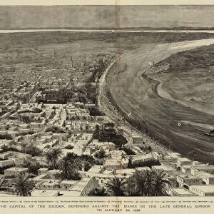
Metal Print : Map of Khartoum and vicinity at the time of siege of Khartoum 1884


![]()
Metal Prints from Fine Art Storehouse
Map of Khartoum and vicinity at the time of siege of Khartoum 1884
Vintage illustration of Map of Khartoum and vicinity at the time of siege of Khartoum 1884
Unleash your creativity and transform your space into a visual masterpiece!
duncan1890
Media ID 21157915
© of Duncan P Walker
British Army Mahdist Mahdist War
10"x8" (25x20cm) Table Top Metal Print
Step back in time with our vintage Map of Khartoum and Vicinity from the Fine Art Storehouse by duncan1890. This captivating Metal Print depicts the region during the fateful Siege of Khartoum in 1884. The intricate details and authentic illustration style transport you to a bygone era. Perfectly preserved and presented on high-quality metal, this unique piece is not only a beautiful addition to your home decor but also a fascinating historical artifact. Bring history to life with the Media Storehouse Metal Prints collection.
Table Top Metal Prints feature rounded corners and an easel back for easy display. Available in two sizes, 18x13cm (7x5) or 25x20cm (10x8). Lightweight and vibrant, they are perfect for displaying artwork and are guaranteed to add style to any desk or table top. The unique material is fade, moisture, chemical and scratch resistant to help ensure this art lasts a lifetime.
Made with durable metal and luxurious printing techniques, metal prints bring images to life and add a modern touch to any space
Estimated Product Size is 25.4cm x 20.3cm (10" x 8")
These are individually made so all sizes are approximate
Artwork printed orientated as per the preview above, with landscape (horizontal) or portrait (vertical) orientation to match the source image.
FEATURES IN THESE COLLECTIONS
> Fine Art Storehouse
> History
> Battles & Wars
> Historcal Battle Maps and Plans
> Maps and Charts
> Related Images
EDITORS COMMENTS
This vintage illustration captures a fascinating piece of history - the Map of Khartoum and vicinity during the infamous Siege of Khartoum in 1884. The print showcases intricate details, providing a glimpse into the strategic landscape that defined this pivotal moment in time. The British army, led by General Charles Gordon, found themselves besieged by Mahdist forces during the Mahdist War. This conflict marked a significant chapter in Sudan's struggle for independence from colonial rule. As we examine this map, it becomes evident how crucial geography was to both sides involved. Duncan1890's artistic rendering beautifully brings forth the intricacies of this historical event. The attention to detail is remarkable; every contour and landmark is meticulously depicted, allowing us to visualize the challenges faced by both armies. This print serves as a reminder of the sacrifices made by soldiers on both sides and offers an opportunity for reflection on past conflicts that have shaped our world today. It invites viewers to delve into history and explore not only military strategies but also cultural dynamics at play during this era. Whether you are an avid history enthusiast or simply appreciate fine art, this print will transport you back in time to witness one of Sudan's most significant battles unfold before your eyes.
MADE IN AUSTRALIA
Safe Shipping with 30 Day Money Back Guarantee
FREE PERSONALISATION*
We are proud to offer a range of customisation features including Personalised Captions, Color Filters and Picture Zoom Tools
SECURE PAYMENTS
We happily accept a wide range of payment options so you can pay for the things you need in the way that is most convenient for you
* Options may vary by product and licensing agreement. Zoomed Pictures can be adjusted in the Cart.