Metal Print > Europe > France > Paris > Maps
Metal Print : Europe physical map 1887


![]()
Metal Prints from Fine Art Storehouse
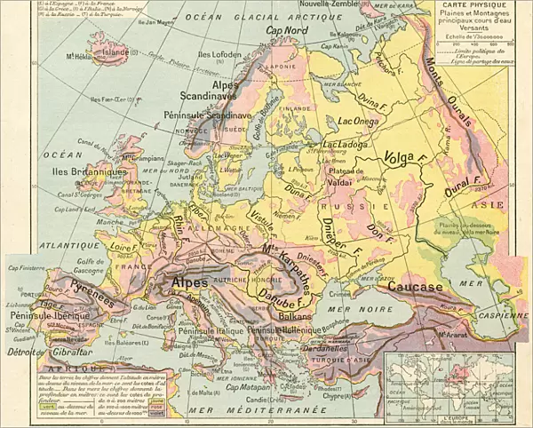
Europe physical map 1887
Map from La Premiere Annee de Geographie par P. Foncin - Paris 1887
Unleash your creativity and transform your space into a visual masterpiece!
THEPALMER
Media ID 19834471
© 2014 Roberto Adrian Photography
10"x8" (25x20cm) Table Top Metal Print
Discover the rich history of Europe with our stunning Metal Print of the 1887 Physical Map by THEPALMER from the Media Storehouse Fine Art collection. This intricately detailed map, originally published in "La Premiere Annee de Geographie" by P. Foncin in Paris, showcases the political boundaries and geographical features of Europe during that time. The high-quality Metal Print brings an elegant and timeless touch to any space, while the vibrant colors and crisp details ensure a captivating visual experience. Bring a piece of historical cartography into your home or office.
Table Top Metal Prints feature rounded corners and an easel back for easy display. Available in two sizes, 18x13cm (7x5) or 25x20cm (10x8). Lightweight and vibrant, they are perfect for displaying artwork and are guaranteed to add style to any desk or table top. The unique material is fade, moisture, chemical and scratch resistant to help ensure this art lasts a lifetime.
Made with durable metal and luxurious printing techniques, metal prints bring images to life and add a modern touch to any space
Estimated Product Size is 25.4cm x 20.3cm (10" x 8")
These are individually made so all sizes are approximate
Artwork printed orientated as per the preview above, with landscape (horizontal) or portrait (vertical) orientation to match the source image.
FEATURES IN THESE COLLECTIONS
> Fine Art Storehouse
> Map
> Historical Maps
> Europe
> France
> Paris
> Maps
> Europe
> Related Images
> Maps and Charts
> Related Images
EDITORS COMMENTS
This print showcases a remarkable piece of history - the Europe physical map from 1887. A true gem for geography enthusiasts and history buffs alike, this map is a testament to the meticulous craftsmanship of its time. The fine details and intricate design are beautifully preserved in this high-quality print by THEPALMER, available exclusively at Fine Art Storehouse. As we gaze upon this vintage map, we are transported back to an era where exploration and discovery were at their peak. Every contour of Europe's diverse landscape comes alive through vibrant colors and precise cartographic techniques. From the majestic Alps to the vast plains of Russia, each region is meticulously labeled with cities, rivers, mountains, and borders. The significance of this historical artifact cannot be overstated. It not only serves as a visual representation of Europe's physical features but also offers valuable insights into how our understanding of geography has evolved over time. This particular edition was published in Paris in 1887 as part of "La Premiere Annee de Geographie" by P. Foncin. Whether you're an avid traveler or simply appreciate the beauty found within maps, this stunning print will make a striking addition to any space. Let it ignite your curiosity about European landscapes past and present while adding a touch of vintage charm to your home or office décor.
MADE IN AUSTRALIA
Safe Shipping with 30 Day Money Back Guarantee
FREE PERSONALISATION*
We are proud to offer a range of customisation features including Personalised Captions, Color Filters and Picture Zoom Tools
SECURE PAYMENTS
We happily accept a wide range of payment options so you can pay for the things you need in the way that is most convenient for you
* Options may vary by product and licensing agreement. Zoomed Pictures can be adjusted in the Cart.