Metal Print > Maps and Charts > Africa
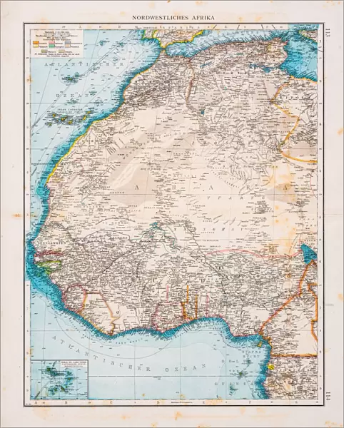
Metal Print : Map of North Africa 1896


![]()
Metal Prints from Fine Art Storehouse
Map of North Africa 1896
Andres Allgemeiner Handatlas - Bielefeld und Leipzig 1896
Unleash your creativity and transform your space into a visual masterpiece!
THEPALMER
Media ID 18356803
10"x8" (25x20cm) Table Top Metal Print
Discover the captivating history of North Africa with our exquisite Metal Print of the Map of North Africa 1896 by THEPALMER from the Media Storehouse Fine Art Collection. This intricately detailed map, originally published in Andres Allgemeiner Handatlas in 1896, showcases the political boundaries and geographical features of North Africa during a pivotal time in history. With our premium Metal Print, you'll bring a piece of historical cartography into your home or office, enhancing any decor while providing a fascinating conversation starter. The vibrant colors and sharp details pop against the sleek, modern metal surface, ensuring a stunning visual display. Elevate your space with a touch of history and artistry - order your North Africa 1896 Metal Print today.
Table Top Metal Prints feature rounded corners and an easel back for easy display. Available in two sizes, 18x13cm (7x5) or 25x20cm (10x8). Lightweight and vibrant, they are perfect for displaying artwork and are guaranteed to add style to any desk or table top. The unique material is fade, moisture, chemical and scratch resistant to help ensure this art lasts a lifetime.
Made with durable metal and luxurious printing techniques, metal prints bring images to life and add a modern touch to any space
Estimated Product Size is 20.3cm x 25.4cm (8" x 10")
These are individually made so all sizes are approximate
Artwork printed orientated as per the preview above, with landscape (horizontal) or portrait (vertical) orientation to match the source image.
FEATURES IN THESE COLLECTIONS
> Fine Art Storehouse
> Map
> Historical Maps
> Africa
> Related Images
> Maps and Charts
> Related Images
EDITORS COMMENTS
This print showcases a remarkable piece of history, the "Map of North Africa 1896" from Andres Allgemeiner Handatlas. A true testament to cartographic excellence, this map transports us back in time to an era when exploration and discovery were at their peak. With intricate details and precise craftsmanship, it offers a window into the geopolitical landscape of North Africa during the late 19th century. The map's vibrant colors and meticulous labeling bring forth a wealth of information about the region's diverse topography, cities, rivers, and borders. It serves as both an educational tool for geography enthusiasts and a nostalgic reminder of how our understanding of the world has evolved over time. Expertly captured by THEPALMER and presented as a high-quality print by Fine Art Storehouse, this image allows us to appreciate not only the historical significance but also the artistic beauty that lies within old maps. The delicate lines etched onto aged paper evoke a sense of wonderment as we contemplate the countless journeys taken across these lands. Whether displayed in classrooms or personal spaces, this print is sure to spark curiosity and ignite conversations about North Africa's rich cultural heritage. As we gaze upon this masterpiece from 1896 with awe-inspired eyes, let us celebrate its ability to bridge past and present while reminding us that knowledge truly knows no bounds.
MADE IN AUSTRALIA
Safe Shipping with 30 Day Money Back Guarantee
FREE PERSONALISATION*
We are proud to offer a range of customisation features including Personalised Captions, Color Filters and Picture Zoom Tools
SECURE PAYMENTS
We happily accept a wide range of payment options so you can pay for the things you need in the way that is most convenient for you
* Options may vary by product and licensing agreement. Zoomed Pictures can be adjusted in the Cart.