Poster Print > Maps and Charts > Africa
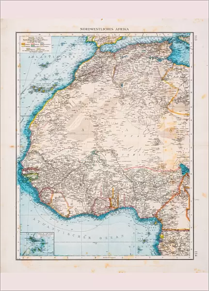
Poster Print : Map of North Africa 1896


![]()
Poster Prints from Fine Art Storehouse
Map of North Africa 1896
Andres Allgemeiner Handatlas - Bielefeld und Leipzig 1896
Unleash your creativity and transform your space into a visual masterpiece!
THEPALMER
Media ID 18356803
A3 (42 x 29.7cm) Poster Print
Step back in time with our stunning Map of North Africa 1896 print from THEPALMER's Fine Art Storehouse collection. This captivating poster, taken from Andres Allgemeiner Handatlas published in Bielefeld and Leipzig in 1896, offers a fascinating glimpse into historical geography. The intricate detail and vintage aesthetic make this poster an elegant addition to any home or office space, transporting you to a bygone era. Bring history to life with this beautiful and authentic piece of art.
Premium quality poster prints are printed on luxurious semi-gloss satin 270 gsm paper. Our meticulously crafted poster prints offer an affordable option for decorating any space, making them ideal for living rooms, bedrooms, offices and beyond. To ensure your poster arrives in good condition, we roll and send them in strong mailing tubes.
Poster prints are budget friendly enlarged prints in standard poster paper sizes (A0, A1, A2, A3 etc). Whilst poster paper is sometimes thinner and less durable than our other paper types, they are still ok for framing and should last many years. Our Archival Quality Photo Prints and Fine Art Paper Prints are printed on higher quality paper and the choice of which largely depends on your budget.
Estimated Product Size is 30.6cm x 42.6cm (12" x 16.8")
These are individually made so all sizes are approximate
Artwork printed orientated as per the preview above, with portrait (vertical) orientation to match the source image.
FEATURES IN THESE COLLECTIONS
> Fine Art Storehouse
> Map
> Historical Maps
> Africa
> Related Images
> Maps and Charts
> Related Images
EDITORS COMMENTS
This print showcases a remarkable piece of history, the "Map of North Africa 1896" from Andres Allgemeiner Handatlas. A true testament to cartographic excellence, this map transports us back in time to an era when exploration and discovery were at their peak. With intricate details and precise craftsmanship, it offers a window into the geopolitical landscape of North Africa during the late 19th century. The map's vibrant colors and meticulous labeling bring forth a wealth of information about the region's diverse topography, cities, rivers, and borders. It serves as both an educational tool for geography enthusiasts and a nostalgic reminder of how our understanding of the world has evolved over time. Expertly captured by THEPALMER and presented as a high-quality print by Fine Art Storehouse, this image allows us to appreciate not only the historical significance but also the artistic beauty that lies within old maps. The delicate lines etched onto aged paper evoke a sense of wonderment as we contemplate the countless journeys taken across these lands. Whether displayed in classrooms or personal spaces, this print is sure to spark curiosity and ignite conversations about North Africa's rich cultural heritage. As we gaze upon this masterpiece from 1896 with awe-inspired eyes, let us celebrate its ability to bridge past and present while reminding us that knowledge truly knows no bounds.
MADE IN AUSTRALIA
Safe Shipping with 30 Day Money Back Guarantee
FREE PERSONALISATION*
We are proud to offer a range of customisation features including Personalised Captions, Color Filters and Picture Zoom Tools
SECURE PAYMENTS
We happily accept a wide range of payment options so you can pay for the things you need in the way that is most convenient for you
* Options may vary by product and licensing agreement. Zoomed Pictures can be adjusted in the Cart.