Metal Print > Historic > Ancient civilizations > Roman Empire > Roman art
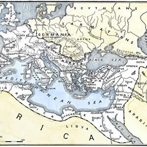
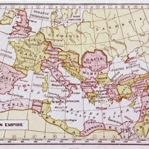
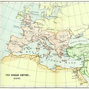
Metal Print : Map of the Roman Empire 1889


![]()
Metal Prints from Fine Art Storehouse
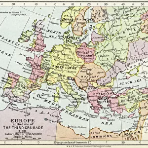
Map of the Roman Empire 1889
Comprehensive Geography by James Monteith - American Book Company 1882, 1889
Unleash your creativity and transform your space into a visual masterpiece!
THEPALMER
Media ID 18357279
10"x8" (25x20cm) Table Top Metal Print
Step back in time with our stunning Metal Print of the Map of the Roman Empire 1889 by THEPALMER from our Media Storehouse collection. This intricately detailed map, originally published in Comprehensive Geography by James Monteith of the American Book Company in 1882 and 1889, is brought to life in a modern and vibrant way with our high-quality metal print. The metallic finish adds depth and dimension to the historical map, making it a unique and eye-catching addition to any room. With its rich history and beautiful design, this metal print is sure to be a conversation starter and a cherished piece in your home or office decor.
Table Top Metal Prints feature rounded corners and an easel back for easy display. Available in two sizes, 18x13cm (7x5) or 25x20cm (10x8). Lightweight and vibrant, they are perfect for displaying artwork and are guaranteed to add style to any desk or table top. The unique material is fade, moisture, chemical and scratch resistant to help ensure this art lasts a lifetime.
Made with durable metal and luxurious printing techniques, metal prints bring images to life and add a modern touch to any space
Estimated Product Size is 25.4cm x 20.3cm (10" x 8")
These are individually made so all sizes are approximate
Artwork printed orientated as per the preview above, with landscape (horizontal) or portrait (vertical) orientation to match the source image.
FEATURES IN THESE COLLECTIONS
> Fine Art Storehouse
> Map
> Historical Maps
> Arts
> Artists
> R
> Roman Roman
> Historic
> Ancient civilizations
> Roman Empire
> Roman art
> Maps and Charts
> Related Images
EDITORS COMMENTS
This print showcases a remarkable piece of history - the "Map of the Roman Empire 1889". A true treasure for enthusiasts and scholars alike, this map was originally featured in James Monteith's renowned publication, "Comprehensive Geography" released by the American Book Company in 1882. The intricate details and meticulous craftsmanship of this map are brought to life through THEPALMER's exceptional photography. Transporting us back to an era long gone, this snapshot invites us to explore the vast expanse of one of history's greatest empires. From Britannia in the west to Mesopotamia in the east, every corner is meticulously charted with precision and accuracy. Each city, river, and mountain range is intricately labeled, providing a comprehensive understanding of Rome's expansive reach. The sepia tones add a touch of nostalgia to this already awe-inspiring artwork. As we gaze upon it, we can't help but marvel at how far humanity has come since those ancient times. It serves as a reminder that even great civilizations rise and fall but leave behind legacies that continue to shape our world today. Whether you're an avid historian or simply appreciate fine artistry, this print allows you to bring home a piece of ancient grandeur. Hang it on your wall or gift it to someone who shares your passion for exploration; either way, let yourself be transported back centuries as you immerse yourself in the splendorous Map of the Roman Empire from 1889 captured by THE
MADE IN AUSTRALIA
Safe Shipping with 30 Day Money Back Guarantee
FREE PERSONALISATION*
We are proud to offer a range of customisation features including Personalised Captions, Color Filters and Picture Zoom Tools
SECURE PAYMENTS
We happily accept a wide range of payment options so you can pay for the things you need in the way that is most convenient for you
* Options may vary by product and licensing agreement. Zoomed Pictures can be adjusted in the Cart.