Metal Print > Europe > Switzerland > Maps
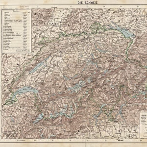
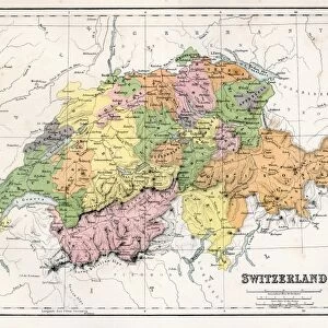
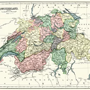
Metal Print : Map of Switzerland 1889


![]()
Metal Prints from Fine Art Storehouse
Map of Switzerland 1889
Comprehensive Geography by James Monteith - American Book Company 1882, 1889
Unleash your creativity and transform your space into a visual masterpiece!
THEPALMER
Media ID 18357277
10"x8" (25x20cm) Table Top Metal Print
Experience the rich history of cartography with our Media Storehouse Metal Print of the Map of Switzerland 1889 by THEPALMER. This exquisite piece is derived from the Comprehensive Geography book published by the American Book Company in 1882 and 1889. The intricate details of the map are brought to life through our high-quality Metal Print, which not only enhances the visual appeal but also adds a modern and stylish touch to any space. Each Metal Print is meticulously crafted using premium metal sheets, ensuring a long-lasting and vibrant display. Transport yourself back in time and add a touch of historical charm to your home or office with this unique and captivating Map of Switzerland 1889 by THEPALMER from our Fine Art Storehouse collection.
Table Top Metal Prints feature rounded corners and an easel back for easy display. Available in two sizes, 18x13cm (7x5) or 25x20cm (10x8). Lightweight and vibrant, they are perfect for displaying artwork and are guaranteed to add style to any desk or table top. The unique material is fade, moisture, chemical and scratch resistant to help ensure this art lasts a lifetime.
Made with durable metal and luxurious printing techniques, metal prints bring images to life and add a modern touch to any space
Estimated Product Size is 25.4cm x 20.3cm (10" x 8")
These are individually made so all sizes are approximate
Artwork printed orientated as per the preview above, with landscape (horizontal) or portrait (vertical) orientation to match the source image.
FEATURES IN THESE COLLECTIONS
> Fine Art Storehouse
> Map
> Historical Maps
> Europe
> Switzerland
> Maps
> Europe
> Switzerland
> Posters
> Europe
> Switzerland
> Related Images
> Maps and Charts
> Related Images
> Maps and Charts
> Switzerland
EDITORS COMMENTS
This print showcases a remarkable piece of history, the "Map of Switzerland 1889" from James Monteith's Comprehensive Geography. Published in 1882 and updated in 1889 by the American Book Company, this map offers a fascinating glimpse into the past. With its intricate details and exquisite craftsmanship, it transports us back to an era when cartography was both an art form and a scientific endeavor. The Map of Switzerland depicted here is not just a geographical representation but also a testament to human curiosity and exploration. It invites us to embark on a visual journey through the Swiss landscape, with its majestic mountains, serene lakes, charming towns, and winding rivers. Each contour line meticulously drawn reminds us of the challenges faced by early explorers who sought to understand and document our world. As we gaze upon this vintage treasure expertly captured by THEPALMER for Fine Art Storehouse, we are reminded of how maps have always held immense significance throughout history. They have guided adventurers across uncharted territories while igniting dreams of discovery within those who dared to dream big. Whether you are an avid collector or simply appreciate historical artifacts that tell stories beyond words, this print will undoubtedly captivate your imagination. Let it transport you back in time as you explore every detail etched onto its surface – each stroke representing countless hours spent unraveling nature's secrets.
MADE IN AUSTRALIA
Safe Shipping with 30 Day Money Back Guarantee
FREE PERSONALISATION*
We are proud to offer a range of customisation features including Personalised Captions, Color Filters and Picture Zoom Tools
SECURE PAYMENTS
We happily accept a wide range of payment options so you can pay for the things you need in the way that is most convenient for you
* Options may vary by product and licensing agreement. Zoomed Pictures can be adjusted in the Cart.