Metal Print > Europe > Russia > Maps
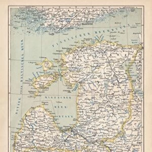
Metal Print : Map of West Russia and Baltic sea 1896


![]()
Metal Prints from Fine Art Storehouse
Map of West Russia and Baltic sea 1896
Andres Allgemeiner Handatlas - Bielefeld und Leipzig 1896
Unleash your creativity and transform your space into a visual masterpiece!
THEPALMER
Media ID 18357069
10"x8" (25x20cm) Table Top Metal Print
Discover history through art with our stunning Metal Print of the Map of West Russia and the Baltic Sea by THEPALMER from our Media Storehouse Fine Art collection. This intricately detailed map, originally published in Andres Allgemeiner Handatlas in 1896, showcases the geography of the region during a pivotal time in history. Each Metal Print is meticulously crafted, bringing the rich colors and textures of the original map to life. The sleek, modern metal finish adds a contemporary touch to this timeless piece, making it a captivating addition to any home or office decor. Bring history into your space and ignite your imagination with our high-quality, museum-grade Metal Print of the Map of West Russia and the Baltic Sea by THEPALMER.
Table Top Metal Prints feature rounded corners and an easel back for easy display. Available in two sizes, 18x13cm (7x5) or 25x20cm (10x8). Lightweight and vibrant, they are perfect for displaying artwork and are guaranteed to add style to any desk or table top. The unique material is fade, moisture, chemical and scratch resistant to help ensure this art lasts a lifetime.
Made with durable metal and luxurious printing techniques, metal prints bring images to life and add a modern touch to any space
Estimated Product Size is 25.4cm x 20.3cm (10" x 8")
These are individually made so all sizes are approximate
Artwork printed orientated as per the preview above, with landscape (horizontal) or portrait (vertical) orientation to match the source image.
FEATURES IN THESE COLLECTIONS
> Fine Art Storehouse
> Map
> Historical Maps
> Europe
> Russia
> Related Images
> Maps and Charts
> Related Images
EDITORS COMMENTS
In this print titled "Map of West Russia and Baltic Sea 1896" we are transported back in time to the late 19th century. The image, sourced from Andres Allgemeiner Handatlas - Bielefeld und Leipzig 1896, offers a glimpse into the intricate cartography of that era. The map showcases the vast expanse of West Russia and its surrounding regions, including the Baltic Sea. With meticulous detail, it presents an array of cities, towns, rivers, and mountain ranges that were significant landmarks during that period. Each line drawn with precision tells a story of exploration and discovery. As we delve deeper into this historical artifact captured by THEPALMER for Fine Art Storehouse, our imagination takes flight. We can envision explorers poring over maps like these as they embarked on daring expeditions or navigated treacherous waters. Beyond its geographical significance lies the artistic beauty inherent in this print. The sepia tones lend an air of nostalgia to the piece while enhancing its vintage charm. The delicate lines and ornate typography evoke a sense of craftsmanship rarely seen today. This print is not just a mere representation; it is a testament to human curiosity and ingenuity—a reminder that maps have always been more than just tools for navigation but also gateways to understanding our world's past and present.
MADE IN AUSTRALIA
Safe Shipping with 30 Day Money Back Guarantee
FREE PERSONALISATION*
We are proud to offer a range of customisation features including Personalised Captions, Color Filters and Picture Zoom Tools
SECURE PAYMENTS
We happily accept a wide range of payment options so you can pay for the things you need in the way that is most convenient for you
* Options may vary by product and licensing agreement. Zoomed Pictures can be adjusted in the Cart.