Metal Print > Europe > Italy > Lazio > Marino
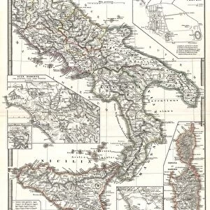
Metal Print : Antique Map of Lower Italy


![]()
Metal Prints from Fine Art Storehouse
Antique Map of Lower Italy
Unleash your creativity and transform your space into a visual masterpiece!
Nastasic
Media ID 21086589
© Nikola Nastasic
Abruzzi Aging Process Basilicata Region Biological Culture Calabria Central Europe Chart Condition Corsica Equipment European Culture Geographical Locations Image Created 1830 1839 Italian Culture Lombardy Magna Graecia Navigational Equipment Puglia Roma Province Rome Italy Sardinia Sicily Southern Europe Tuscany Umbria Veneto Venice Italy Image Created 19th Century Victorian Style
10"x8" (25x20cm) Table Top Metal Print
Discover the timeless charm of history with our Media Storehouse Metal Print of the Antique Map of Lower Italy by Nastasic from Fine Art Storehouse. This exquisite piece showcases intricate cartographic details of the region, transporting you back in time. The high-quality metal print process ensures vibrant colors and exceptional clarity, making each line and detail pop. With a sleek, modern design and durable, rust-resistant metal surface, this print is not only a beautiful addition to your home or office decor but also a long-lasting investment. Bring history to life with the Antique Map of Lower Italy Metal Print from Media Storehouse.
Table Top Metal Prints feature rounded corners and an easel back for easy display. Available in two sizes, 18x13cm (7x5) or 25x20cm (10x8). Lightweight and vibrant, they are perfect for displaying artwork and are guaranteed to add style to any desk or table top. The unique material is fade, moisture, chemical and scratch resistant to help ensure this art lasts a lifetime.
Made with durable metal and luxurious printing techniques, metal prints bring images to life and add a modern touch to any space
Estimated Product Size is 25.4cm x 20.3cm (10" x 8")
These are individually made so all sizes are approximate
Artwork printed orientated as per the preview above, with landscape (horizontal) or portrait (vertical) orientation to match the source image.
FEATURES IN THESE COLLECTIONS
> Fine Art Storehouse
> Map
> Historical Maps
> Fine Art Storehouse
> Map
> Italian Maps
> Europe
> Italy
> Abruzzi
> Related Images
> Europe
> Italy
> Basilicata
> Related Images
> Europe
> Italy
> Calabria
> Related Images
> Europe
> Italy
> Lazio
> Marino
> Europe
> Italy
> Lazio
> Rome
> Europe
> Italy
> Lombardy
> Related Images
> Europe
> Italy
> Puglia
> Related Images
> Europe
> Italy
> Related Images
EDITORS COMMENTS
This print titled "Antique Map of Lower Italy" takes us on a journey back in time to the 19th century. Created between 1830 and 1839, this image showcases the rich European culture and style of that era. The map highlights various regions including Magna Graecia, Roma Province, Sardinia, Venice Italy, Umbria, Tuscany, Sicily, San Marino Italy, Lombardy, Rome Italy, Calabria, Basilicata Region, Puglia Abruzzi. The aging process has added a touch of Victorian charm to this piece as it beautifully captures the history and essence of Italian culture. From the grandeur of ancient Rome to the picturesque landscapes of Tuscany and Veneto's enchanting canals in Venice - each region is meticulously detailed. This map not only serves as a geographical reference but also provides insight into navigational equipment used during that period. It reminds us how maps were once essential tools for exploration and discovery. With its intricate details and artistic flair reminiscent of biological cultures found in nature itself; this print transports us to an era long gone by. It invites contemplation about our past while celebrating the beauty and diversity of Southern Europe. Nastasic's creation offers a glimpse into European history through an exquisite fusion of artistry and cartography. Whether displayed in homes or offices alike; this antique map serves as a timeless reminder of our ever-evolving world while adding elegance to any space it graces.
MADE IN AUSTRALIA
Safe Shipping with 30 Day Money Back Guarantee
FREE PERSONALISATION*
We are proud to offer a range of customisation features including Personalised Captions, Color Filters and Picture Zoom Tools
SECURE PAYMENTS
We happily accept a wide range of payment options so you can pay for the things you need in the way that is most convenient for you
* Options may vary by product and licensing agreement. Zoomed Pictures can be adjusted in the Cart.