Metal Print > Arts > Artists > I > Italian School Italian School
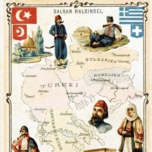
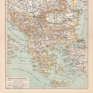
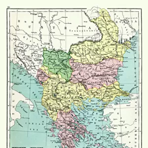
Metal Print : Map of Central Europe 1895


![]()
Metal Prints from Fine Art Storehouse
Map of Central Europe 1895
The Rand-McNally Grammar School Geography 1895 - Chicago & New York
Unleash your creativity and transform your space into a visual masterpiece!
THEPALMER
Media ID 14824625
© This content is subject to copyright
Austria Bulgaria Denmark Portugal Russia Serbia Sweden
10"x8" (25x20cm) Table Top Metal Print
Step back in time with our exquisite Metal Print of the Map of Central Europe 1895 by THEPALMER from the Media Storehouse Fine Art Collection. This vintage map, originally published by Rand-McNally for the Grammar School Geography in 1895, adds an intriguing touch of history to any space. The intricate details of the map are beautifully preserved in high definition, making it a captivating conversation starter. The sleek, modern metal print material enhances the visual appeal and durability of this timeless piece, ensuring it remains a cherished addition to your home or office decor. Bring a piece of the past into the present with our Central European Map Metal Print from Media Storehouse.
Table Top Metal Prints feature rounded corners and an easel back for easy display. Available in two sizes, 18x13cm (7x5) or 25x20cm (10x8). Lightweight and vibrant, they are perfect for displaying artwork and are guaranteed to add style to any desk or table top. The unique material is fade, moisture, chemical and scratch resistant to help ensure this art lasts a lifetime.
Made with durable metal and luxurious printing techniques, metal prints bring images to life and add a modern touch to any space
Estimated Product Size is 20.3cm x 25.4cm (8" x 10")
These are individually made so all sizes are approximate
Artwork printed orientated as per the preview above, with landscape (horizontal) or portrait (vertical) orientation to match the source image.
FEATURES IN THESE COLLECTIONS
> Fine Art Storehouse
> Map
> Denmark Maps
> Fine Art Storehouse
> Map
> Historical Maps
> Fine Art Storehouse
> Map
> Italian Maps
> Arts
> Artists
> I
> Italian School Italian School
> Arts
> Artists
> P
> Portuguese School
> Arts
> Artists
> S
> Spanish School
> Europe
> Austria
> Related Images
> Europe
> Bulgaria
> Related Images
EDITORS COMMENTS
In this print titled "Map of Central Europe 1895" artist THEPALMER takes us on a journey back in time to the late 19th century. The image showcases an intricately detailed map from "The Rand-McNally Grammar School Geography 1895" publication, originating from Chicago and New York. With its vintage charm, the map transports us to a bygone era when borders were different and nations had yet to experience significant geopolitical changes. We can trace our fingers across Portugal's western coast, Austria's majestic peaks, Bulgaria's rich cultural heritage, Denmark's picturesque landscapes, and many more iconic European destinations. This historical snapshot invites us to explore the diverse tapestry of Central Europe as it stood over a century ago. From France's romantic allure to Germany's industrial prowess, Italy's artistic legacy to Russia's vast expanse – each country holds its own unique story waiting to be discovered. As we gaze upon this remarkable piece of artistry, we are reminded of the power maps have in shaping our understanding of the world around us. They serve as windows into history while igniting our curiosity about distant lands and cultures. "The Map of Central Europe 1895" by THEPALMER is not just a mere depiction; it is an invitation for exploration and reflection on how our world has evolved throughout time. It serves as a reminder that beneath political boundaries lie shared histories that connect all humanity together.
MADE IN AUSTRALIA
Safe Shipping with 30 Day Money Back Guarantee
FREE PERSONALISATION*
We are proud to offer a range of customisation features including Personalised Captions, Color Filters and Picture Zoom Tools
SECURE PAYMENTS
We happily accept a wide range of payment options so you can pay for the things you need in the way that is most convenient for you
* Options may vary by product and licensing agreement. Zoomed Pictures can be adjusted in the Cart.