Fraud Blocker Skip to main content

Home > Europe > Austria > Maps

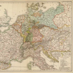
Map of central Europe 1889

Map of central Europe 1889
Sold 1
In Stock
We accept all major credit cards
Framed Photos
Buy from AU$119.99
Photo Prints
Buy from AU$12.99
Jigsaw Puzzles
Buy from AU$89.99
Poster Prints
Buy from AU$24.99
Canvas Prints
Buy from AU$124.99
Fine Art Prints
Buy from AU$92.53
Metal Prints
Buy from AU$43.99
Cards
Buy from AU$12.99
Home Decor
Buy from AU$24.99

Fine Art Storehouse Photo Prints and Wall Art

Map of central Europe 1889

Indiana Educational Series The Complete Geography - Indianapolis 1889. Unleash your creativity and transform your space into a visual masterpiece. © This content is subject to copyright

THEPALMER

Media ID 14756322

Austria Denmark Norway Portugal Russia Sweden

FEATURES IN THESE COLLECTIONS

> Europe > Austria > Maps

> Europe > Austria > Posters

> Europe > Austria > Related Images

> Europe > Denmark > Maps

> Europe > Denmark > Posters

> Europe > Denmark > Related Images

> Europe > France > Maps

> Europe > Germany > Maps

> Europe > Germany > Posters

> Europe > Germany > Related Images

> Fine Art Storehouse > Map > Denmark Maps

> Fine Art Storehouse > Map > Historical Maps

> Fine Art Storehouse > Map > Italian Maps

> Fine Art Storehouse > Map

SECURE PAYMENTS
We happily accept a wide range of payment options so you can pay for the things you need in the way that is most convenient for you

MADE IN AUSTRALIA
Safe Shipping with 30 Day Money Back Guarantee

FREE PERSONALISATION
We are proud to offer a range of customisation including Cropping, Captions, and Filters. Zoom Cropping can be adjusted in the Basket.


EDITORS COMMENTS

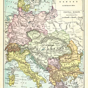
This print titled "Map of Central Europe 1889" takes us on a journey back in time to the late 19th century. The image showcases an authentic reproduction of a map from the Indiana Educational Series, specifically "The Complete Geography - Indianapolis 1889". With intricate details and vibrant colors, this piece offers a glimpse into the geographical landscape of central Europe during that era. As we delve into the composition, our eyes are immediately drawn to Portugal, Austria, Denmark, France, Germany, Italy, Norway, Russia, Spain and Sweden. Each country is meticulously outlined with delicate precision and labeled with elegant typography. This historical artifact not only serves as a visual representation of the region's boundaries but also provides valuable insights into political divisions and territorial claims at that time. "The Map of Central Europe 1889" by THEPALMER transports us to an age where cartography was both artistry and science. It invites us to appreciate how knowledge was disseminated through beautifully crafted maps like these. Whether displayed in a classroom or cherished within one's personal collection, this print evokes nostalgia for an era when exploration and discovery were paramount. With its rich historical significance and meticulous attention to detail captured by Fine Art Storehouse photographers' expertise; this artwork becomes more than just a decorative piece—it becomes a gateway to understanding our past while appreciating the beauty found within educational resources such as maps.


Framed Prints

Step back in time with our exquisite Framed Print of "Map of Central Europe 1889" by THEPALMER from the Indianapolis Fine Art Storehouse. Part of the Indiana Educational Series, this vintage map takes you on a journey through history with its intricate details and authentic cartography. Bring a touch of nostalgia and classic charm to your home or office decor, while adding a unique educational piece to your collection. Each print is carefully framed with premium materials to preserve its beauty and authenticity for years to come.


Photo Prints

Step back in time with our exquisite reproduction of "Map of Central Europe 1889" by THEPALMER from the Indiana Educational Series The Complete Geography, published in Indianapolis. This Fine Art Storehouse photographic print brings history to life, offering a captivating glimpse into the geography of Central Europe during the late 19th century. Perfect for history enthusiasts, educators, or anyone who appreciates the beauty of vintage maps, this print is a unique addition to your home or office decor. The intricate details of this antique map are beautifully preserved in our high-quality photographic print, ensuring a stunning and authentic presentation.


Poster Prints

"Step back in time with our vintage Map of Central Europe 1889 print from ThePalmer's Indiana Educational Series The Complete Geography, published in Indianapolis in 1889. This exquisite poster print, available from Media Storehouse's Fine Art Storehouse, showcases intricate details of Europe's political and geographical landscape during the late 19th century. Ideal for history enthusiasts, educators, or those who appreciate the beauty of historical cartography, this print makes a stunning addition to any room. Bring a piece of the past into your home or office today."


Jigsaw Puzzles

Discover the historical wonders of central Europe with our intricately designed jigsaw puzzle from Media Storehouse. Featuring the detailed and captivating Map of Central Europe 1889 by THEPALMER from the Indianapolis 1889 edition of The Complete Geography series by Fine Art Storehouse. This educational puzzle invites you to immerse yourself in the rich history and cultural diversity of the region. Piece together the intricate borders, cities, and landmarks of central Europe, making this puzzle an engaging and rewarding experience for history enthusiasts, geography buffs, and puzzle lovers alike. Connect with the past as you explore the intricacies of this beautiful and informative puzzle.

diamond
Made With High Grade Materials
thumb_up
Professional Quality Finish
package_2
Carefully Packed To Aid Safe Arrival

You May Also Like


Map of Central Europe 1895Map of Central Europe 1895
Add to Basket
Comic map of Europe by Frederick Rose, c. 1870 (litho)Comic map of Europe by Frederick Rose, c. 1870 (litho)
Add to Basket
Map of Europe 1721Map of Europe 1721
Add to Basket
Map of Europe 1889Map of Europe 1889
Add to Basket
Old Map of the World 1871Old Map of the World 1871
Add to Basket
Maps / World / HerodotusMaps / World / Herodotus
Add to Basket
Maps / World / EratosthenesMaps / World / Eratosthenes
Add to Basket
Crusades MapCrusades Map
Add to Basket
Map / Roman Empire / CupMap / Roman Empire / Cup
Add to Basket
Map of Central Europe, World War OneMap of Central Europe, World War One
Add to Basket
Dado PrsoDado Prso
Add to Basket
Arsene Wenger the Arsenal Manager. Arsenal 4: 2 Wigan AthleticArsene Wenger the Arsenal Manager. Arsenal 4: 2 Wigan Athletic
Add to Basket

Gallery Wall Inspiration

Italy Map - illustration
Italy country map
Sicily map 1895
Roman Republic and Carthage during the Second Punic War (218-201-BC)
Europe Map with France, Portugal, Spain and Netherlands
Italy Reference Map
Antique colored illustrations: Geological map of England and Wales
Cartoon map of ITALY
Antique Damaged Map of Italy 19th Century
Antquie Map of Italy
Map of Venice 1897
City map of Florence, Italy, lithograph, published in 1897
Austro-Hungarian Empire, Habsburg Monarchy, lithograph, published in 1877
Travels of The Apostle Paul Map Engraving
Vintage map of Magna Graecia
Bosnia, dalmatia, istria, croatia, slavonia
Antique Map of Italy, with detail of straits of Messina, 19th Century
Map of Naples and surrounding, Campania, Italy, lithograph, published 1897
Gaul in the time of Julius Caesar, published in 1867
City map of Rome, lithograph, published in 1878
Italy map 1875
Map of Venice 1898
Europe map 1867
Map of Capri, Italian island, wood engraving published in 1897
old map of europe
Map of central Europe 1889
Floor plan of Palatine Hill in Rome, published in 1878

Discover Our Collections


MapMap
View Collection
Denmark MapsDenmark Maps
View Collection
Austria Related ImagesAustria Related Images
View Collection
Denmark Related ImagesDenmark Related Images
View Collection
Germany Related ImagesGermany Related Images
View Collection
MapsMaps
View Collection
MapsMaps
View Collection
MapsMaps
View Collection
MapsMaps
View Collection
PostersPosters
View Collection
PostersPosters
View Collection
PostersPosters
View Collection
Italian MapsItalian Maps
View Collection
Historical MapsHistorical Maps
View Collection


© Copyright Media Storehouse, All Rights Reserved 2003 - 2024
Facebook     Pinterest     Card Payments     Reviews IO