Metal Print > North America > United States of America > New York > New York > Maps
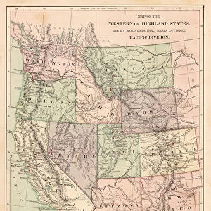
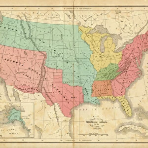
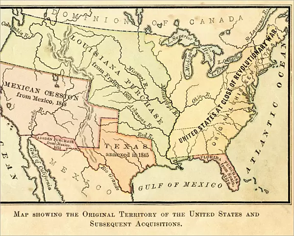
Metal Print : Map of the original USA territory 1881


![]()
Metal Prints from Fine Art Storehouse
Map of the original USA territory 1881
Appletons American Standard Geographies - New York 1881 - d. Appleton and Company
Unleash your creativity and transform your space into a visual masterpiece!
THEPALMER
Media ID 18356667
10"x8" (25x20cm) Table Top Metal Print
Step back in time with our vintage Map of the Original USA Territory from 1881, part of our Media Storehouse Metal Print collection. This beautiful piece, sourced from the renowned Appletons American Standard Geographies published by Appleton and Company in New York, is meticulously reproduced onto a high-quality metal print. The distressed metal finish adds an authentic, timeless touch to this historical map, making it a unique and captivating addition to any home or office decor. Travel back to an era of exploration and discovery with this intricately detailed and historically significant piece.
Table Top Metal Prints feature rounded corners and an easel back for easy display. Available in two sizes, 18x13cm (7x5) or 25x20cm (10x8). Lightweight and vibrant, they are perfect for displaying artwork and are guaranteed to add style to any desk or table top. The unique material is fade, moisture, chemical and scratch resistant to help ensure this art lasts a lifetime.
Made with durable metal and luxurious printing techniques, metal prints bring images to life and add a modern touch to any space
Estimated Product Size is 25.4cm x 20.3cm (10" x 8")
These are individually made so all sizes are approximate
Artwork printed orientated as per the preview above, with landscape (horizontal) or portrait (vertical) orientation to match the source image.
FEATURES IN THESE COLLECTIONS
> Fine Art Storehouse
> Map
> Historical Maps
> Fine Art Storehouse
> Map
> USA Maps
> Maps and Charts
> Related Images
> North America
> United States of America
> Maps
> North America
> United States of America
> New York
> New York
> Maps
> North America
> United States of America
> New York
> Related Images
EDITORS COMMENTS
Map of the original USA territory 1881 (Appletons American Standard Geographies - New York 1881 - d. Appleton and Company) (954897424) by THEPALMER captures a fascinating snapshot of America's historical landscape. This beautifully detailed print, available at Fine Art Storehouse, takes us back to the year 1881 when the United States was still in its formative years. The map showcases the vast expanse of territories that comprised the nation during this pivotal era. From coast to coast, it highlights each state and region with intricate precision, offering a glimpse into how borders were defined and evolving at that time. The attention to detail is remarkable; one can almost imagine exploring these uncharted lands through this visual masterpiece. This particular edition from Appletons American Standard Geographies holds great significance as it represents an important milestone in cartography history. Published by d. Appleton and Company in New York, this map served as an educational tool for generations of students studying geography across America. THEPALMER's expertly captured photograph ensures that every minute detail is preserved faithfully on this high-quality print. Whether you are a history enthusiast or simply appreciate fine art, this piece will undoubtedly spark curiosity about our country's past while adding elegance to any space it graces.
MADE IN AUSTRALIA
Safe Shipping with 30 Day Money Back Guarantee
FREE PERSONALISATION*
We are proud to offer a range of customisation features including Personalised Captions, Color Filters and Picture Zoom Tools
SECURE PAYMENTS
We happily accept a wide range of payment options so you can pay for the things you need in the way that is most convenient for you
* Options may vary by product and licensing agreement. Zoomed Pictures can be adjusted in the Cart.