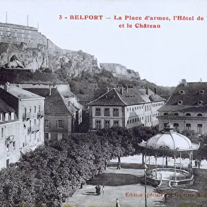
Metal Print > Europe > France > Canton > Belfort
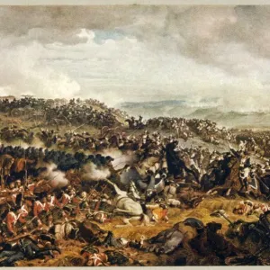
Metal Print : Map of the Battle of Belfort, 15 January 1871, (c1872). Creator: R. Walker
. Creator: R. Walker")


![]()
Metal Prints from Heritage Images
Map of the Battle of Belfort, 15 January 1871, (c1872). Creator: R. Walker
Map of the Battle of Belfort, 15 January 1871, (c1872). Map: Drawn under the Superintendence of Captain Hozier, showing the enemy positions. Prussian forces assaulted and blockaded the French garrison of Belfort from November 1870 until February 1871. On 15 February an armistice was signed between France and Germany. From " The Franco-Prussian War: its causes, incidents and consequences", Volume II, by Captain H M Hozier. [William Mackenzie, London, 1872]
Heritage Images features heritage image collections
Media ID 19778735
© The Print Collector/Heritage Images
1870 1871 Adversary Belfort Canal Doubs Enemy Franche Comte Franco Prussian War Front Line Frontline H M Hozier Henry Montague Henry Montague Hozier Hozier Lines Mackenzie Prussia Prussian Prussian Army R Walker Robert Walker Sir Henry Montagu Hozier Walker William Mackenzie Battlefield Montbeliard
14"x11" (28x35cm) Metal Print
Step back in time with our stunning Metal Print of the Battle of Belfort Map, dated 1872. This intricately detailed historical map, created by R. Walker under the supervision of Captain Hozier, depicts the strategic positions of both sides during the Battle of Belfort on January 15, 1871. Bring the history of this significant military engagement into your home or office with our high-quality Metal Print. The vibrant colors and sharp lines of the map are beautifully preserved in this durable and modern format, making it a unique and captivating addition to any space. Order now and relive the history of this pivotal moment in time.
Our Metal Prints feature rounded corners and rear fixings for easy wall mounting. Images are directly printed onto a lightweight, high quality 5mm thick, durable metallic surface for a vivid and vibrant finish. Available in 2 sizes, 28x35cm (14x11) and 50x40cm (20x16). The unique material is fade, moisture, chemical and scratch resistant to help ensure this art lasts a lifetime.
Made with durable metal and luxurious printing techniques, metal prints bring images to life and add a modern touch to any space
Estimated Product Size is 35.5cm x 27.9cm (14" x 11")
These are individually made so all sizes are approximate
Artwork printed orientated as per the preview above, with landscape (horizontal) or portrait (vertical) orientation to match the source image.
FEATURES IN THESE COLLECTIONS
> Animals
> Mammals
> Muridae
> Water Mouse
> Arts
> Artists
> W
> Robert Walker
> Arts
> Artists
> W
> Robert White
> Arts
> Artists
> W
> William White
> Europe
> France
> Canton
> Belfort
> Europe
> France
> Canton
> Doubs
> Europe
> France
> Canton
> Rhone
> Historic
> Battles
> Related Images
EDITORS COMMENTS
This print showcases the "Map of the Battle of Belfort, 15 January 1871" created by R. Walker in approximately 1872. The map, drawn under the supervision of Captain Hozier, provides a detailed depiction of enemy positions during this significant event in history. The Battle of Belfort took place during the Franco-Prussian War, where Prussian forces launched an assault on the French garrison located in Belfort from November 1870 to February 1871. This strategic blockade led to intense warfare between two powerful adversaries. The print transports us back to the nineteenth century, offering a glimpse into the complex world of military tactics and territorial disputes. It highlights how water transport played a crucial role in this battle as canals are prominently featured on the map. With its intricate details and precise markings, this historical document serves as a valuable resource for understanding one chapter within a larger conflict that shaped European history. Its inclusion in Captain H. M. Hozier's book "The Franco-Prussian War: its causes, incidents and consequences" further solidifies its significance. As we observe this remarkable piece of artistry by Robert Walker and appreciate William Mackenzie's publishing efforts in London during that era, we gain insight into not only the physical landscape but also into the minds behind military strategies employed during times of war.
MADE IN AUSTRALIA
Safe Shipping with 30 Day Money Back Guarantee
FREE PERSONALISATION*
We are proud to offer a range of customisation features including Personalised Captions, Color Filters and Picture Zoom Tools
SECURE PAYMENTS
We happily accept a wide range of payment options so you can pay for the things you need in the way that is most convenient for you
* Options may vary by product and licensing agreement. Zoomed Pictures can be adjusted in the Cart.