Metal Print > Arts > Artists > T > John Tallis
Metal Print : New Zealand 1851


![]()
Metal Prints from MapSeeker
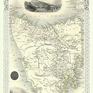
New Zealand 1851
A fine facimile artworked from an antique original map of New Zealand, issued as part of the 1851 edition of John Tallis and Companys " The Illustrated Atlas and Modern History of the World"
Welcome to the Mapseeker Image library and enter an historic gateway to one of the largest on-line collections of Historic Maps, Nostalgic Views, Vista's and Panorama's from a World gone by.
Media ID 20347525
© Mapseeker Publishing Ltd
John Tallis John Tallis Map Tallis Map
14"x11" (28x35cm) Metal Print
Step back in time with Media Storehouse's Metal Prints featuring the exquisite 1851 map of New Zealand by John Tallis and John Rapkin from MapSeeker. This fine facsimile artwork, meticulously reproduced from an antique original map, offers a captivating glimpse into the history of this beautiful country. The intricate details of the map's topography, geographical features, and early place names are brought to life in vivid detail on a sleek, durable metal print. Add a touch of history and elegance to your home or office decor with this unique and intriguing piece.
Our Metal Prints feature rounded corners and rear fixings for easy wall mounting. Images are directly printed onto a lightweight, high quality 5mm thick, durable metallic surface for a vivid and vibrant finish. Available in 2 sizes, 28x35cm (14x11) and 50x40cm (20x16). The unique material is fade, moisture, chemical and scratch resistant to help ensure this art lasts a lifetime.
Made with durable metal and luxurious printing techniques, metal prints bring images to life and add a modern touch to any space
Estimated Product Size is 27.9cm x 35.5cm (11" x 14")
These are individually made so all sizes are approximate
Artwork printed orientated as per the preview above, with landscape (horizontal) or portrait (vertical) orientation to match the source image.
FEATURES IN THESE COLLECTIONS
> MapSeeker
> Maps of Africa and Oceana
> Old Maps of New Zealand, Tasmania And
> Arts
> Artists
> T
> John Tallis
> Maps and Charts
> Related Images
> Maps and Charts
> World
> Oceania
> New Zealand
> Maps
> Oceania
> New Zealand
> Related Images
EDITORS COMMENTS
This exquisite print showcases a remarkable piece of history - a fine facsimile artworked from an antique original map of New Zealand dating back to 1851. This map was originally issued as part of the prestigious 1851 edition of John Tallis and Company's "The Illustrated Atlas and Modern History of the World". With intricate details and stunning craftsmanship, this old map offers a glimpse into the past, allowing us to explore the early geography and boundaries of New Zealand. The carefully drawn coastlines, rivers, mountains, and settlements provide a fascinating insight into how this beautiful country appeared over 150 years ago. Created by renowned cartographers John Tallis and John Rapkin, this historic New Zealand map is not only aesthetically pleasing but also serves as an important historical document. It captures the spirit of exploration that characterized the era when maps were meticulously crafted by hand. Whether you are an avid collector or simply appreciate artistry combined with historical significance, this print is sure to captivate your imagination. Display it proudly in your home or office to spark conversations about New Zealand's rich heritage and its place in global history
MADE IN AUSTRALIA
Safe Shipping with 30 Day Money Back Guarantee
FREE PERSONALISATION*
We are proud to offer a range of customisation features including Personalised Captions, Color Filters and Picture Zoom Tools
SECURE PAYMENTS
We happily accept a wide range of payment options so you can pay for the things you need in the way that is most convenient for you
* Options may vary by product and licensing agreement. Zoomed Pictures can be adjusted in the Cart.