Metal Print > Aerial Photography > Related Images
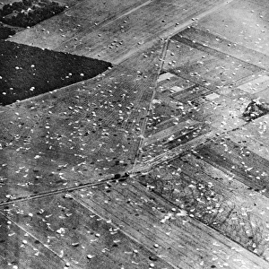
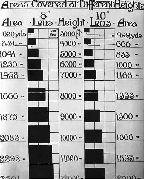
Metal Print : Areas Covered at Different Heights for 1: 20, 000 Scale Ve?


![]()
Metal Prints from Mary Evans Picture Library
Areas Covered at Different Heights for 1: 20, 000 Scale Ve?
Areas Covered at Different Heights for 1:20, 000 Scale Vertical Images - Early Years of Aerial-Photography History - Instructions Date: 1910s
Mary Evans Picture Library makes available wonderful images created for people to enjoy over the centuries
Media ID 18412926
© aviation-images.com / Mary Evans Picture Library
Air To Ground Archive Days Histories Olden Past Rafaerial
10"x8" (25x20cm) Table Top Metal Print
Step into the early years of aerial photography history with our stunning Metal Prints from Media Storehouse, featuring the captivating image "Areas Covered at Different Heights for 1:20, 000 Scale" from Mary Evans Prints Online. These vertical images, dating back to the 1910s, offer a unique glimpse into the past, showcasing the evolution of aerial photography. Our high-quality Metal Prints bring the intricate details and vibrant colors of this Rights Managed image to life, making it a beautiful addition to any home or office space. With a sturdy and durable metal construction, these prints are not only visually appealing but also long-lasting. Elevate your decor and transport yourself back in time with Media Storehouse Metal Prints.
Table Top Metal Prints feature rounded corners and an easel back for easy display. Available in two sizes, 18x13cm (7x5) or 25x20cm (10x8). Lightweight and vibrant, they are perfect for displaying artwork and are guaranteed to add style to any desk or table top. The unique material is fade, moisture, chemical and scratch resistant to help ensure this art lasts a lifetime.
Made with durable metal and luxurious printing techniques, metal prints bring images to life and add a modern touch to any space
Estimated Product Size is 20.3cm x 25.4cm (8" x 10")
These are individually made so all sizes are approximate
Artwork printed orientated as per the preview above, with landscape (horizontal) or portrait (vertical) orientation to match the source image.
FEATURES IN THESE COLLECTIONS
> Mary Evans Prints Online
> Aviation Images
> Aerial Photography
> Related Images
EDITORS COMMENTS
This photograph print, hailing from the early years of aerial photography history, showcases the 'Areas Covered at Different Heights for 1:20,000 Scale Vertical Images' produced by the Royal Flying Corps (RFC) and later the Royal Air Force (RAF) in the United Kingdom during the 1910s. The RFC and RAF were pioneers in the use of aerial photography for military reconnaissance, and this series of images represents an essential part of their early archives. The photograph depicts a collection of vertical aerial views taken from various heights, providing a unique perspective of the ground below. The 1:20,000 scale indicates a relatively large area coverage, making these images valuable for mapping and surveying purposes. The vintage aesthetic of the photograph adds to its historical significance, transporting us back to the olden days of aerial photography. The image is an intriguing blend of the past and the present, offering a glimpse into the early history of aerial photography and its role in military intelligence gathering. The meticulously planned and executed aerial surveys showcase the attention to detail and precision that were hallmarks of the RFC and RAF's early operations. This photograph print is a testament to the ingenuity and innovation of the early aviators and photographers who pushed the boundaries of technology to gather valuable information from the skies. It is a fascinating addition to any collection of historical, vintage, or aviation-themed prints.
MADE IN AUSTRALIA
Safe Shipping with 30 Day Money Back Guarantee
FREE PERSONALISATION*
We are proud to offer a range of customisation features including Personalised Captions, Color Filters and Picture Zoom Tools
FREE COLORIZATION SERVICE
You can choose advanced AI Colorization for this picture at no extra charge!
SECURE PAYMENTS
We happily accept a wide range of payment options so you can pay for the things you need in the way that is most convenient for you
* Options may vary by product and licensing agreement. Zoomed Pictures can be adjusted in the Cart.