Metal Print : Map / Asia / Tibet Etc 1845


![]()
Metal Prints from Mary Evans Picture Library
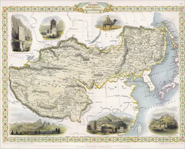
Map / Asia / Tibet Etc 1845
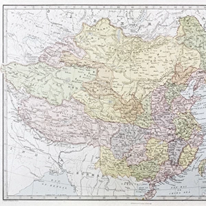
Map of Tibet, Mongolia and Manchuria
Mary Evans Picture Library makes available wonderful images created for people to enjoy over the centuries
Media ID 608839
© Mary Evans Picture Library 2015 - https://copyrighthub.org/s0/hub1/creation/maryevans/MaryEvansPictureID/10114140
1845 Manchuria Maps Mongolia Tibet
10"x8" (25x20cm) Table Top Metal Print
Discover the captivating beauty of ancient cartography with our Media Storehouse Metal Prints featuring the Map of Tibet, Mongolia, and Manchuria from Mary Evans Picture Library, dated 1845. This intricately detailed map, sourced from Mary Evans Prints Online, showcases the rich history and geography of Asia during an era of exploration and discovery. Each Metal Print is meticulously crafted using high-definition printing technology and a durable, rust-resistant metal sheet, ensuring a vibrant, long-lasting display that adds character and depth to any space. Bring the intrigue of 19th-century cartography into your home or office with this stunning, collectible piece.
Table Top Metal Prints feature rounded corners and an easel back for easy display. Available in two sizes, 18x13cm (7x5) or 25x20cm (10x8). Lightweight and vibrant, they are perfect for displaying artwork and are guaranteed to add style to any desk or table top. The unique material is fade, moisture, chemical and scratch resistant to help ensure this art lasts a lifetime.
Made with durable metal and luxurious printing techniques, metal prints bring images to life and add a modern touch to any space
Estimated Product Size is 25.4cm x 20.3cm (10" x 8")
These are individually made so all sizes are approximate
Artwork printed orientated as per the preview above, with landscape (horizontal) or portrait (vertical) orientation to match the source image.
EDITORS COMMENTS
This stunning historical print from Mary Evans Picture Library takes us back to the year 1845, showcasing a detailed map of Tibet, Mongolia, and Manchuria in Asia. The intricate details on the map provide a glimpse into the geography and boundaries of these regions during that time period.
The map not only serves as a valuable historical document but also offers insight into the political landscape of Asia in the mid-19th century. It highlights the vast expanse of Tibet, with its mountainous terrain and remote location, as well as the neighboring regions of Mongolia and Manchuria.
As we study this fascinating piece of cartography, we are transported to a different era when exploration and discovery were at the forefront of human endeavor. The meticulous craftsmanship evident in every line and symbol on the map is a testament to the skill and dedication of those who created it.
Whether you have an interest in history, geography, or simply appreciate fine artistry, this print is sure to captivate your imagination. It serves as a reminder of how maps have played a crucial role in shaping our understanding of the world around us. Take a closer look at this Map / Asia / Tibet Etc 1845 print from Mary Evans Prints Online and embark on a journey through time and space.
MADE IN AUSTRALIA
Safe Shipping with 30 Day Money Back Guarantee
FREE PERSONALISATION*
We are proud to offer a range of customisation features including Personalised Captions, Color Filters and Picture Zoom Tools
SECURE PAYMENTS
We happily accept a wide range of payment options so you can pay for the things you need in the way that is most convenient for you
* Options may vary by product and licensing agreement. Zoomed Pictures can be adjusted in the Cart.