Metal Print > Maps and Charts > Related Images
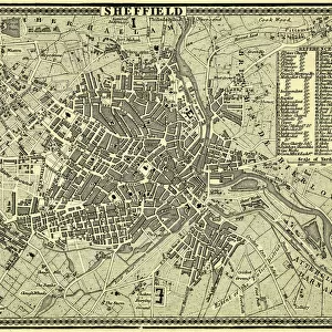
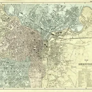
Metal Print : Map of the Town and Environs of Sheffield, 1864


![]()
Metal Prints from Sheffield City Archives
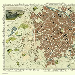
Map of the Town and Environs of Sheffield, 1864
Scale 1 inches : 1 mile. Board and church schools have been indicated at a later date and the ecclesiastical districts have been indicated by colouring.Original at Sheffield Archives ref. SY18/1
Sheffield City Archives and Local Studies Library has an unrivalled collection of images of Sheffield, England
Media ID 13987657
© Sheffield City Council
10"x8" (25x20cm) Table Top Metal Print
Step back in time with our stunning Metal Print of the Map of Sheffield and Its Environs from 1864. This intricately detailed map, sourced from Sheffield City Archives, offers a captivating glimpse into the history of this vibrant city. With a scale of 1 inch : 1 mile, this map showcases the town's layout, including board and church schools, ecclesiastical districts, and other key landmarks. Each Metal Print is meticulously crafted, bringing the historical map to life with vivid colors and a sleek, modern finish. Perfect for history enthusiasts, local residents, or anyone who appreciates the beauty of vintage maps, this Metal Print makes a unique and thoughtful gift. Order yours today and bring a piece of Sheffield's rich history into your home or office.
Table Top Metal Prints feature rounded corners and an easel back for easy display. Available in two sizes, 18x13cm (7x5) or 25x20cm (10x8). Lightweight and vibrant, they are perfect for displaying artwork and are guaranteed to add style to any desk or table top. The unique material is fade, moisture, chemical and scratch resistant to help ensure this art lasts a lifetime.
Made with durable metal and luxurious printing techniques, metal prints bring images to life and add a modern touch to any space
Estimated Product Size is 25.4cm x 20.3cm (10" x 8")
These are individually made so all sizes are approximate
Artwork printed orientated as per the preview above, with landscape (horizontal) or portrait (vertical) orientation to match the source image.
FEATURES IN THESE COLLECTIONS
> Maps and Charts
> Related Images
> Sheffield City Archives
> Maps and Plans
> Maps of Sheffield
EDITORS COMMENTS
This print showcases the intricate "Map of the Town and Environs of Sheffield" dating back to 1864. With a scale of 1 inch to 1 mile, this meticulously detailed map offers a fascinating glimpse into the city's past. The print highlights various landmarks such as board and church schools, which have been indicated at a later date, providing valuable insights into Sheffield's educational landscape during that era. What sets this particular map apart is its unique color-coded representation of ecclesiastical districts. Each district has been carefully colored, allowing viewers to easily identify and understand the religious divisions within Sheffield in 1864. This visual depiction adds an extra layer of historical significance to the map, shedding light on how religion played an integral role in shaping communities during that time. Preserved at Sheffield Archives under reference SY18/1, this original piece holds immense value for historians, researchers, and anyone interested in exploring Sheffield's rich heritage. It serves as a tangible link between our present-day understanding of the city and its vibrant past
MADE IN AUSTRALIA
Safe Shipping with 30 Day Money Back Guarantee
FREE PERSONALISATION*
We are proud to offer a range of customisation features including Personalised Captions, Color Filters and Picture Zoom Tools
SECURE PAYMENTS
We happily accept a wide range of payment options so you can pay for the things you need in the way that is most convenient for you
* Options may vary by product and licensing agreement. Zoomed Pictures can be adjusted in the Cart.