
Metal Print > Universal Images Group (UIG) > Universal Images Group > Satellite and Aerial > Planet Observer 4
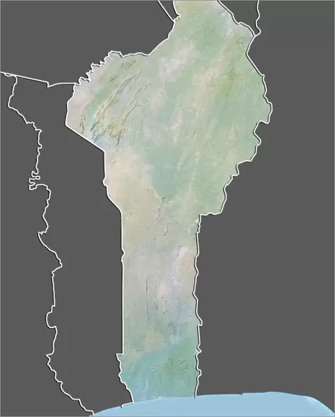
Metal Print : Benin, Relief Map With Border and Mask


![]()
Metal Prints from Universal Images Group (UIG)
Benin, Relief Map With Border and Mask
Relief map of Benin (with border and mask). This image was compiled from data acquired by landsat 5 & 7 satellites combined with elevation data
Universal Images Group (UIG) manages distribution for many leading specialist agencies worldwide
Media ID 9618589
© Planet Observer/UIG
Africa Benin Coastline Relief Map Shore Cotonou Gulf Of Guinea Niger River Porto Novo Satellite View
10"x8" (25x20cm) Table Top Metal Print
Discover the rich cultural heritage of Benin with our stunning Metal Prints from Media Storehouse. This captivating image, sourced from Universal Images Group (UIG), features a relief map of Benin, complete with its distinctive border and iconic Benin Mask. Meticulously compiled from data acquired by Landsat 5 & 7 satellites, this print showcases the intricate topography of the region in exquisite detail. Elevation data brings the landscape to life, creating a visually striking and educational piece for your home or office. Experience the beauty and history of Benin like never before with our high-quality Metal Prints.
Table Top Metal Prints feature rounded corners and an easel back for easy display. Available in two sizes, 18x13cm (7x5) or 25x20cm (10x8). Lightweight and vibrant, they are perfect for displaying artwork and are guaranteed to add style to any desk or table top. The unique material is fade, moisture, chemical and scratch resistant to help ensure this art lasts a lifetime.
Made with durable metal and luxurious printing techniques, metal prints bring images to life and add a modern touch to any space
Estimated Product Size is 20.3cm x 25.4cm (8" x 10")
These are individually made so all sizes are approximate
Artwork printed orientated as per the preview above, with landscape (horizontal) or portrait (vertical) orientation to match the source image.
EDITORS COMMENTS
This print showcases the intricate beauty of Benin, a West African country known for its rich history and diverse landscapes. The image depicts a relief map of Benin, meticulously crafted using data acquired by Landsat 5 & 7 satellites combined with elevation information. The vibrant colors and detailed contours bring to life the physical geography of this enchanting nation. From the stunning coastline along the Gulf of Guinea to the meandering Niger River, every feature is accurately represented in this visually striking composition. The border surrounding the relief map adds an artistic touch, while a mask placed strategically on top further emphasizes Benin's cultural heritage and traditional art forms. This fusion of cartography and symbolism creates a truly unique piece that captures both geographical accuracy and cultural significance. With no people present in the photograph, viewers are invited to immerse themselves in the natural beauty and topography of Benin. The image transports us outdoors, allowing us to appreciate the vastness of this land from Porto Novo to Cotonou. Whether you have an interest in photography or simply admire aerial views, this print offers a fascinating glimpse into one corner of Africa's diverse landscape – showcasing why Benin is truly a hidden gem waiting to be explored.
MADE IN AUSTRALIA
Safe Shipping with 30 Day Money Back Guarantee
FREE PERSONALISATION*
We are proud to offer a range of customisation features including Personalised Captions, Color Filters and Picture Zoom Tools
SECURE PAYMENTS
We happily accept a wide range of payment options so you can pay for the things you need in the way that is most convenient for you
* Options may vary by product and licensing agreement. Zoomed Pictures can be adjusted in the Cart.