Metal Print > Europe > France > Canton > Bas Rhin
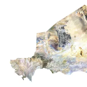
Metal Print : Guinea-Bissau, Satellite Image


![]()
Metal Prints from Universal Images Group (UIG)
Guinea-Bissau, Satellite Image
Satellite view of Guinea-Bissau. This image was compiled from data acquired by LANDSAT satellite
Universal Images Group (UIG) manages distribution for many leading specialist agencies worldwide
Media ID 9612205
© Planet Observer
Alsace Bas Rhin Geographical Border Relief Map Satellite View
10"x8" (25x20cm) Table Top Metal Print
Discover the unique beauty of Guinea-Bissau with our Media Storehouse Metal Prints. This stunning satellite image from Universal Images Group (UIG) captures the intricate details of the Guinea-Bissau landscape, compiled from data acquired by LANDSAT satellite. Our high-quality metal prints are not just a picture, they're a work of art. The vivid colors and exceptional clarity are brought to life on a durable, lightweight metal surface that's waterproof, scratch-resistant, and easy to clean. Hang it in your home or office and let the captivating satellite view of Guinea-Bissau transport you to another world. Order now and experience the difference of our premium metal prints.
Table Top Metal Prints feature rounded corners and an easel back for easy display. Available in two sizes, 18x13cm (7x5) or 25x20cm (10x8). Lightweight and vibrant, they are perfect for displaying artwork and are guaranteed to add style to any desk or table top. The unique material is fade, moisture, chemical and scratch resistant to help ensure this art lasts a lifetime.
Made with durable metal and luxurious printing techniques, metal prints bring images to life and add a modern touch to any space
Estimated Product Size is 25.4cm x 20.3cm (10" x 8")
These are individually made so all sizes are approximate
Artwork printed orientated as per the preview above, with landscape (horizontal) or portrait (vertical) orientation to match the source image.
FEATURES IN THESE COLLECTIONS
> Africa
> Guinea-Bissau
> Bissau
> Europe
> France
> Canton
> Bas Rhin
> Europe
> France
> Canton
> Rhin
> Maps and Charts
> Related Images
> Universal Images Group (UIG)
> Universal Images Group
> Satellite and Aerial
> Planet Observer 6
EDITORS COMMENTS
This print showcases the stunning satellite view of Guinea-Bissau, a West African country known for its rich cultural heritage and diverse landscapes. Compiled from data acquired by the LANDSAT satellite, this image offers a unique perspective on the topography and physical geography of Guinea-Bissau. The vibrant colors and intricate details highlight the country's geographical borders, allowing viewers to appreciate its natural beauty. With no people in sight, this photograph emphasizes the untouched wilderness and vastness of Guinea-Bissau's outdoors. From lush forests to winding rivers and sprawling plains, every element is captured with precision, making it an ideal piece for nature enthusiasts or those fascinated by cartography. The vertical composition adds depth to the image while providing a comprehensive overview of Guinea-Bissau's landscape. As you explore this print further, you'll notice how each contour represents different elevations across the region – from mountainous terrains to coastal lowlands. Whether displayed in homes or offices, this print serves as both an artistic masterpiece and an educational tool. It invites viewers to embark on a visual journey through one of Africa's hidden gems – Guinea-Bissau – where culture meets nature in perfect harmony
MADE IN AUSTRALIA
Safe Shipping with 30 Day Money Back Guarantee
FREE PERSONALISATION*
We are proud to offer a range of customisation features including Personalised Captions, Color Filters and Picture Zoom Tools
SECURE PAYMENTS
We happily accept a wide range of payment options so you can pay for the things you need in the way that is most convenient for you
* Options may vary by product and licensing agreement. Zoomed Pictures can be adjusted in the Cart.