Metal Print > Europe > United Kingdom > England > Sussex > Clayton
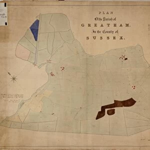
Metal Print : Clayton Tithe Map, c. 1838


![]()
Metal Prints from West Sussex County Council
Clayton Tithe Map, c. 1838
No date, but Tithe Award dated 1838. By Richard Dixon, Surveyor, Godalming. 20 in. to 1 m. Original map size 153in. × 47in.
Tithe Award Map Collection
West Sussex Record Office Ref No: TD/E72
West Sussex County Council Record Office contains a fascinating history of the county of West Sussex, England
Media ID 7915676
© West Sussex County Council - All Rights Reserved
14"x11" (28x35cm) Metal Print
Discover the rich history of West Sussex with our stunning Metal Print of the Clayton Tithe Map, dated 1838. This intricately detailed map, originally surveyed by Richard Dixon of Godalming, offers a fascinating glimpse into the past. With its clear lines and vibrant colors, this Metal Print brings the historical record to life, making it an elegant and unique addition to any home or office. The high-quality metal print is waterproof, scratch-resistant, and UV protected, ensuring your investment remains beautiful for years to come. Bring a piece of West Sussex history into your space with this captivating and durable piece.
Our Metal Prints feature rounded corners and rear fixings for easy wall mounting. Images are directly printed onto a lightweight, high quality 5mm thick, durable metallic surface for a vivid and vibrant finish. Available in 2 sizes, 28x35cm (14x11) and 50x40cm (20x16). The unique material is fade, moisture, chemical and scratch resistant to help ensure this art lasts a lifetime.
Made with durable metal and luxurious printing techniques, metal prints bring images to life and add a modern touch to any space
Estimated Product Size is 27.9cm x 35.5cm (11" x 14")
These are individually made so all sizes are approximate
Artwork printed orientated as per the preview above, with landscape (horizontal) or portrait (vertical) orientation to match the source image.
FEATURES IN THESE COLLECTIONS
> Europe
> United Kingdom
> England
> Sussex
> Clayton
> Europe
> United Kingdom
> England
> Sussex
> Related Images
> Europe
> United Kingdom
> England
> West Sussex
> Related Images
> Maps and Charts
> Early Maps
> Maps and Charts
> Related Images
> West Sussex County Council
> West Sussex Record Office
> Tithe Award Maps, 1808-1859
EDITORS COMMENTS
This print showcases the historical Clayton Tithe Map, dating back to approximately 1838. Created by Richard Dixon, a skilled surveyor from Godalming, this remarkable piece of cartography offers a fascinating glimpse into the past. Measuring an impressive 153 inches by 47 inches in its original form, this reduced-scale reproduction presents the map at a ratio of 20 inches to one meter. Part of the esteemed Tithe Award Map Collection housed at West Sussex Record Office (Ref No: TD/E72), this artifact holds immense value for historians and enthusiasts alike. Its intricate details provide valuable insights into land ownership and usage during the early 19th century. As you explore this image, immerse yourself in the rich history it represents. Transport your mind to a time when Clayton's landscape was shaped differently; when boundaries were defined by stone walls and hedgerows instead of modern landmarks. Imagine farmers tending their fields diligently while village life thrived around them. It is important to note that this photograph is not associated with any commercial use or promotion but rather serves as an educational tool for those interested in historical mapping from the 1830s. Let us cherish these glimpses into our past and appreciate how far we have come since then.
MADE IN AUSTRALIA
Safe Shipping with 30 Day Money Back Guarantee
FREE PERSONALISATION*
We are proud to offer a range of customisation features including Personalised Captions, Color Filters and Picture Zoom Tools
SECURE PAYMENTS
We happily accept a wide range of payment options so you can pay for the things you need in the way that is most convenient for you
* Options may vary by product and licensing agreement. Zoomed Pictures can be adjusted in the Cart.


![Chichester St. Peter the Great [Subdeanery] tithe map, 1846-1847](/sq/479/chichester-st-peter-great-subdeanery-tithe-10701869.jpg.webp)