Mouse Mat > Africa > Comoros > Maps
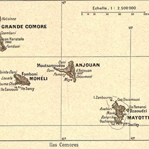
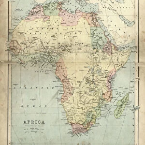
Mouse Mat : Madagascar And Comoros Islands Circa 1760. From Atlas De Toutes Les Parties Connues Du Globe Terrestre By Cartographer Rigobert Bonne Published Geneva Circa 1760


![]()
Home Decor from Design Pics
Madagascar And Comoros Islands Circa 1760. From Atlas De Toutes Les Parties Connues Du Globe Terrestre By Cartographer Rigobert Bonne Published Geneva Circa 1760
Design Pics offers Distinctively Different Imagery representing over 1,500 contributors
Media ID 18196286
© Ken Welsh / Design Pics
18th Bonne Cartography Circa Eighteenth Indian Islands Madagascar Making Comoro Comoros
Mouse Pad
Bring some life into your office, or create a heartfelt gift, with a personalised deluxe Mouse Mat. Made of high-density black foam with a tough, stain-resistant inter-woven cloth cover they will brighten up any home or corporate office.
Archive quality photographic print in a durable wipe clean mouse mat with non slip backing. Works with all computer mice
Estimated Product Size is 19.7cm x 24.2cm (7.8" x 9.5")
These are individually made so all sizes are approximate
Artwork printed orientated as per the preview above, with landscape (horizontal) or portrait (vertical) orientation to match the source image.
FEATURES IN THESE COLLECTIONS
> Africa
> Comoros
> Related Images
> Africa
> Madagascar
> Maps
> Africa
> Madagascar
> Related Images
> Maps and Charts
> Early Maps
> Maps and Charts
> Related Images
EDITORS COMMENTS
This print takes us back in time to the 18th century, specifically around the year 1760. It showcases a detailed map titled "Madagascar And Comoros Islands Circa 1760" from the renowned Atlas De Toutes Les Parties Connues Du Globe Terrestre by cartographer Rigobert Bonne. Published in Geneva during that era, this historical piece of cartography offers a glimpse into the Indian Ocean's rich history. The image depicts an intricate and beautifully crafted map, showcasing both Madagascar and the Comoros Islands. The attention to detail is remarkable, as every contour of these islands is meticulously outlined. This print serves as a testament to Bonne's expertise and dedication to his craft. As we delve into this snapshot from history, it becomes evident that this map was not only created for aesthetic purposes but also played a significant role in navigation and exploration during its time. It served as an invaluable tool for sailors and explorers who ventured through these waters centuries ago. Ken Welsh has skillfully captured this piece of artistry with precision, allowing us to appreciate its historical significance even today. Whether you are a lover of maps or simply intrigued by our world's past, this print transports you back in time while reminding us of the incredible advancements made in cartography over centuries gone by.
MADE IN AUSTRALIA
Safe Shipping with 30 Day Money Back Guarantee
FREE PERSONALISATION*
We are proud to offer a range of customisation features including Personalised Captions, Color Filters and Picture Zoom Tools
SECURE PAYMENTS
We happily accept a wide range of payment options so you can pay for the things you need in the way that is most convenient for you
* Options may vary by product and licensing agreement. Zoomed Pictures can be adjusted in the Cart.