Mouse Mat > Asia > Jordan > Jordan Heritage Sites > Petra
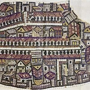
Mouse Mat : Map showing position of Petra (litho)
")

![]()
Home Decor from Fine Art Finder
Map showing position of Petra (litho)
7199405 Map showing position of Petra (litho) by English School, (20th century); Private Collection; (add.info.: Map showing position of Petra. Illustration for Petra, The Rose Red City of Wonder (np, c 1920).); © Look and Learn
Media ID 24728850
© Look and Learn / Bridgeman Images
City Map City Plan Dilapidation Du Soudan General Map Jordan Ruination Ruinous Street Plan Arab Civilization Arabians Central Africa Geographical Map Sudan
Mouse Pad
Bring some life into your office, or create a heartfelt gift, with a personalised deluxe Mouse Mat. Made of high-density black foam with a tough, stain-resistant inter-woven cloth cover they will brighten up any home or corporate office.
Archive quality photographic print in a durable wipe clean mouse mat with non slip backing. Works with all computer mice
Estimated Product Size is 24.2cm x 19.7cm (9.5" x 7.8")
These are individually made so all sizes are approximate
Artwork printed orientated as per the preview above, with landscape (horizontal) or portrait (vertical) orientation to match the source image.
FEATURES IN THESE COLLECTIONS
> Fine Art Finder
> Artists
> English School
> Africa
> Related Images
> Africa
> Sudan
> Related Images
> Animals
> Mammals
> Muridae
> Desert Mouse
> Arts
> Portraits
> Pop art gallery
> Street art portraits
> Asia
> Jordan
> Jordan Heritage Sites
> Petra
> Maps and Charts
> Early Maps
> Maps and Charts
> Related Images
EDITORS COMMENTS
This black and white lithograph, titled "Map showing position of Petra" takes us on a journey through time and space. Created by an English School artist in the early 20th century, this illustration is part of a private collection. The map showcases the geographical location of Petra, also known as "The Rose Red City of Wonder". Situated in Jordan's southwestern desert, this ancient city holds immense historical significance for Arab civilization. The intricate details highlight its importance as a cultural hub connecting Sudan, Africa, and the Middle East. As we explore this mesmerizing map, we are transported to a world filled with ruins that evoke both awe and curiosity. The dilapidated structures depicted here remind us of the passage of time and the impermanence of human creations. Through this lithograph's monochromatic beauty, we can almost feel ourselves stepping into another era. The sense of history emanating from these illustrations is palpable. Every line tells a story; every curve reveals hidden secrets waiting to be discovered. This artwork not only serves as a visual delight but also ignites our imagination about what life might have been like in Petra during its prime. It invites us to delve deeper into cartography and appreciate how maps can provide glimpses into forgotten civilizations. Bridgeman Images has once again brought forth an extraordinary piece from their vast collection – one that captures our senses and transports us to distant lands steeped in mystery and wonder.
MADE IN AUSTRALIA
Safe Shipping with 30 Day Money Back Guarantee
FREE PERSONALISATION*
We are proud to offer a range of customisation features including Personalised Captions, Color Filters and Picture Zoom Tools
SECURE PAYMENTS
We happily accept a wide range of payment options so you can pay for the things you need in the way that is most convenient for you
* Options may vary by product and licensing agreement. Zoomed Pictures can be adjusted in the Cart.