Mouse Mat > Africa > Botswana > Maps
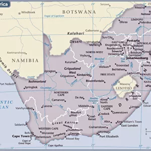
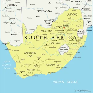
Mouse Mat : Reference Map of Map of South Africa


![]()
Home Decor from Fine Art Storehouse
Reference Map of Map of South Africa
South Africa is located in southern Africa. South Africa is bordered by the Atlantic Ocean and the Indian Ocean, Lesotho and eSwatini (formerly Swaziland) in the eastern portion of South Africa, and Namibia, Botswana, Zimbabwe, and Mozambique to the north
Unleash your creativity and transform your space into a visual masterpiece!
Media ID 20251055
Mouse Pad
Bring some life into your office, or create a heartfelt gift, with a personalised deluxe Mouse Mat. Made of high-density black foam with a tough, stain-resistant inter-woven cloth cover they will brighten up any home or corporate office.
Archive quality photographic print in a durable wipe clean mouse mat with non slip backing. Works with all computer mice
Estimated Product Size is 19.7cm x 24.2cm (7.8" x 9.5")
These are individually made so all sizes are approximate
Artwork printed orientated as per the preview above, with landscape (horizontal) or portrait (vertical) orientation to match the source image.
FEATURES IN THESE COLLECTIONS
> Africa
> Botswana
> Related Images
> Africa
> Lesotho
> Related Images
> Africa
> Mozambique
> Maps
> Africa
> Mozambique
> Related Images
> Africa
> Namibia
> Related Images
> Africa
> Related Images
> Africa
> South Africa
> Maps
EDITORS COMMENTS
This print showcases a meticulously detailed reference map of South Africa, offering a comprehensive glimpse into the diverse landscapes and geographical features that define this remarkable country. Located in southern Africa, South Africa is bordered by both the Atlantic Ocean and the Indian Ocean, creating an awe-inspiring coastline that stretches for miles on end. The map highlights not only the country's extensive shoreline but also its neighboring countries. To the east, Lesotho and eSwatini (formerly Swaziland) form a natural boundary with South Africa, while to the north lie Namibia, Botswana, Zimbabwe, and Mozambique. These nations contribute to South Africa's rich cultural tapestry through shared histories and influences. Every inch of this artful depiction has been thoughtfully crafted to showcase topographical details such as mountain ranges, rivers, lakes, and national parks. It invites viewers to embark on a visual journey across vast plains dotted with vibrant cities like Johannesburg or Cape Town; traverse breathtaking mountainous regions such as Drakensberg; or explore iconic landmarks like Kruger National Park. Whether you are an avid traveler seeking inspiration for your next adventure or simply intrigued by cartography's beauty and precision—this exquisite print from Fine Art Storehouse is sure to captivate your imagination. Its intricate details will transport you directly into South Africa's enchanting world without ever leaving your home.
MADE IN AUSTRALIA
Safe Shipping with 30 Day Money Back Guarantee
FREE PERSONALISATION*
We are proud to offer a range of customisation features including Personalised Captions, Color Filters and Picture Zoom Tools
SECURE PAYMENTS
We happily accept a wide range of payment options so you can pay for the things you need in the way that is most convenient for you
* Options may vary by product and licensing agreement. Zoomed Pictures can be adjusted in the Cart.