Mouse Mat > Science > Space Exploration > Planets > Mars
Mouse Mat : French map of the planet Mars


![]()
Home Decor from Mary Evans Picture Library
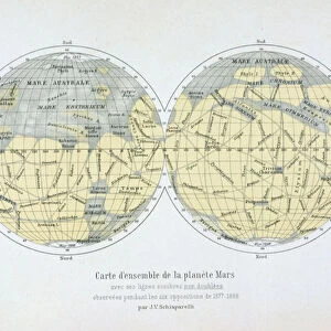
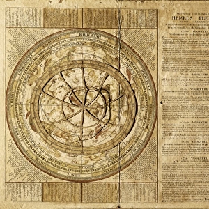
French map of the planet Mars
A French map of the planet Mars, showing two views
Mary Evans Picture Library makes available wonderful images created for people to enjoy over the centuries
Media ID 572460
© Mary Evans Picture Library 2015 - https://copyrighthub.org/s0/hub1/creation/maryevans/MaryEvansPictureID/10005929
Astronomy Mars Patches Phenomena Planet Planets Space Universe
Mouse Pad
Bring some life into your office, or create a heartfelt gift, with a personalised deluxe Mouse Mat. Made of high-density black foam with a tough, stain-resistant inter-woven cloth cover they will brighten up any home or corporate office.
Archive quality photographic print in a durable wipe clean mouse mat with non slip backing. Works with all computer mice
Estimated Product Size is 24.2cm x 19.7cm (9.5" x 7.8")
These are individually made so all sizes are approximate
Artwork printed orientated as per the preview above, with landscape (horizontal) or portrait (vertical) orientation to match the source image.
FEATURES IN THESE COLLECTIONS
> Maps and Charts
> Early Maps
> Maps and Charts
> Related Images
> Science
> Space Exploration
> Planets
> Mars
EDITORS COMMENTS
1. Title: A Glimpse into the Unknown: A French Map of Mars from the 1880s This image presents a pair of views from an intriguing and historical map of Mars, the enigmatic red planet in our solar system. Dated back to the late 1880s, this map, now a precious artifact, was produced by French cartographers and astronomers during a time when the exploration of the universe was a burgeoning field of scientific inquiry. The map's design is a testament to the human curiosity and the quest for knowledge that transcends borders. The two views depicted in the map offer unique perspectives of Mars, one in its natural state and the other as imagined through the lens of 19th-century scientific interpretation. In the first view, the planet's surface is rendered in naturalistic detail, with patches of white, possibly representing polar ice caps or snow-capped volcanoes. The second view, however, presents a more fantastical interpretation, with blue patches and other imagined features that reflect the scientific understanding of the time. The map's antique charm is further accentuated by its white background, which adds a sense of timelessness to the image. The intricate lines and labels, written in French, reveal the meticulous work that went into creating this piece. The map's historical significance lies in its representation of the state of Mars exploration during the late 19th century, a time when the universe was still largely a mystery waiting to be unraveled. As we continue to explore the depths of the universe and uncover new discoveries, this French map of Mars serves as a reminder of the rich history of scientific inquiry and the boundless human curiosity that drives it. This image is a must-have for any collection dedicated to space exploration, astronomy, or the history of cartography.
MADE IN AUSTRALIA
Safe Shipping with 30 Day Money Back Guarantee
FREE PERSONALISATION*
We are proud to offer a range of customisation features including Personalised Captions, Color Filters and Picture Zoom Tools
SECURE PAYMENTS
We happily accept a wide range of payment options so you can pay for the things you need in the way that is most convenient for you
* Options may vary by product and licensing agreement. Zoomed Pictures can be adjusted in the Cart.