Mouse Mat > Europe > United Kingdom > England > Maps
Mouse Mat : London Map / Roman Period


![]()
Home Decor from Mary Evans Picture Library
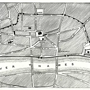
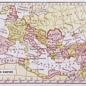
London Map / Roman Period
Map showing Roman London (Londinium) with its grid of straight roads
Mary Evans Picture Library makes available wonderful images created for people to enjoy over the centuries
Media ID 605421
© Mary Evans Picture Library 2015 - https://copyrighthub.org/s0/hub1/creation/maryevans/MaryEvansPictureID/10052955
Mouse Pad
Bring some life into your office, or create a heartfelt gift, with a personalised deluxe Mouse Mat. Made of high-density black foam with a tough, stain-resistant inter-woven cloth cover they will brighten up any home or corporate office.
Archive quality photographic print in a durable wipe clean mouse mat with non slip backing. Works with all computer mice
Estimated Product Size is 24.2cm x 19.7cm (9.5" x 7.8")
These are individually made so all sizes are approximate
Artwork printed orientated as per the preview above, with landscape (horizontal) or portrait (vertical) orientation to match the source image.
FEATURES IN THESE COLLECTIONS
> Arts
> Artists
> R
> Roman Roman
> Europe
> United Kingdom
> England
> London
> Related Images
> Europe
> United Kingdom
> England
> Maps
> Europe
> United Kingdom
> England
> Posters
> Europe
> United Kingdom
> England
> Related Images
> Maps and Charts
> Early Maps
> Maps and Charts
> Related Images
EDITORS COMMENTS
1. Title: A Glimpse into the Past: Roman London's Grid of Straight Roads This print showcases an intriguing map of Roman London, also known as Londinium, during the Roman period. The map, a testament to the rich history of England, reveals the meticulously planned grid of straight roads that once crisscrossed the ancient city. Dating back to around 43 AD, when the Romans first invaded Britain, Londinium served as a significant trading hub and a thriving cultural center. The Romans, renowned for their engineering prowess, designed the city with a well-planned grid system, much like their other colonies across Europe. The map illustrates the main streets and thoroughfares, such as Watling Street, which connected London to the rest of the Roman Empire. The River Thames, a vital source of transportation and commerce, is also depicted, meandering along the southern edge of the city. The Roman period in London was marked by grand public buildings, temples, and bathhouses, many of which were located near the heart of the city. The map provides a fascinating glimpse into the urban layout of this ancient metropolis, offering a unique perspective on how the Romans shaped the city that would later become a global powerhouse. This historical map is an essential resource for scholars, historians, and anyone interested in the fascinating history of London and the Roman Empire. It invites us to explore the past and appreciate the enduring legacy of the Romans in shaping the modern cityscape. In summary, this print of Roman London's grid of straight roads offers a captivating glimpse into the history of England's capital city. The meticulously planned Roman grid system, as depicted in this map, remains an intriguing reminder of the city's rich past and the influence of the Roman Empire on its development.
MADE IN AUSTRALIA
Safe Shipping with 30 Day Money Back Guarantee
FREE PERSONALISATION*
We are proud to offer a range of customisation features including Personalised Captions, Color Filters and Picture Zoom Tools
SECURE PAYMENTS
We happily accept a wide range of payment options so you can pay for the things you need in the way that is most convenient for you
* Options may vary by product and licensing agreement. Zoomed Pictures can be adjusted in the Cart.