Home > North America > United States of America > Washington > Vancouver
EXPL2A-00210

![]()
Wall Art and Photo Gifts from North Wind
EXPL2A-00210
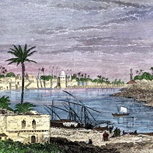
Map of Oregon Territory showing boundary of US with English Canada under dispute until 1846.
Hand-colored woodcut of a 19th-century illustration
North Wind Picture Archives brings history to life with stock images and hand-colored illustrations
Media ID 5877394
© North Wind Picture Archives
Border Boundary British British Columbia Canada Canadian Claim Colony English Land Land Claim North West Oregon Oregon Territory Pacific Pacific Northwest Russian Territory Washington Washington State 1846 Hudson Bay Company Puget Sound Vancouver Island
FEATURES IN THESE COLLECTIONS
> North America
> Canada
> Maps
> North America
> Canada
> Vancouver
> North America
> United States of America
> Washington, District of Columbia
> North America
> United States of America
> Washington
> Vancouver
> North Wind Picture Archives
> American history
> North Wind Picture Archives
> Maps
EDITORS COMMENTS
This hand-colored woodcut print showcases the historical significance of EXPL2A-00210, a map depicting the disputed boundary between the United States and English Canada in the Oregon Territory during the 19th century. The intricate illustration takes us back to a time when land claims were fiercely contested, highlighting an important chapter in American and Canadian history. The map vividly portrays the territorial dispute that persisted until 1846, featuring Washington State, Vancouver Island, British Columbia, and other regions of North America's Pacific Northwest. It serves as a visual testament to the complex negotiations and diplomatic efforts undertaken by both nations to resolve their conflicting claims. With its meticulous details and artistic flair, this vintage print not only provides valuable insights into early colonial expansion but also offers a glimpse into cartographic techniques prevalent in the 1800s. The inclusion of notable landmarks such as Puget Sound and Hudson Bay Company further enhances our understanding of this historic period. As we admire this remarkable piece of artistry from North Wind Picture Archives, it prompts us to reflect on how borders have evolved over time. This image encapsulates an era when national boundaries were fluid and subject to intense scrutiny—a reminder that even seemingly permanent features can be shaped by human negotiation.
MADE IN AUSTRALIA
Safe Shipping with 30 Day Money Back Guarantee
FREE PERSONALISATION*
We are proud to offer a range of customisation features including Personalised Captions, Color Filters and Picture Zoom Tools
SECURE PAYMENTS
We happily accept a wide range of payment options so you can pay for the things you need in the way that is most convenient for you
* Options may vary by product and licensing agreement. Zoomed Pictures can be adjusted in the Cart.