Photo Mug > Europe > Iceland > Maps
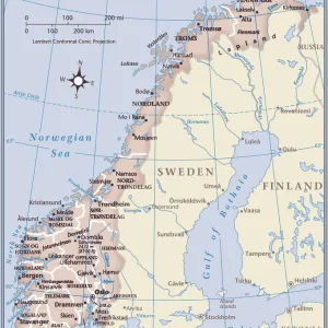
Photo Mug : Antique Map of Sweden, Norway and Denmark


![]()
Home Decor from Fine Art Storehouse
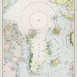
Antique Map of Sweden, Norway and Denmark
Vintage map of Sweden, Norway and Denmark, from 1894
Unleash your creativity and transform your space into a visual masterpiece!
duncan1890
Media ID 13597636
© duncan1890
1890 1899 Denmark Iceland Image Created 1890 1899 Navigational Equipment Nordic Countries Northern Europe Norway Past Retro Revival Scandinavia Sweden Image Created 19th Century Obsolete Retro Styled Scandinavian Peninsula Victorian Style
Photo Mug
"Bring history to your morning routine with our Media Storehouse Photo Mug featuring an exquisite antique map of Sweden, Norway, and Denmark, dated 1894, from the Fine Art Storehouse collection by duncan1890. This vintage map mug not only serves your favorite beverage but also adds a touch of old-world charm to your day. Each mug is printed with high-quality, fade-resistant technology to ensure your map design remains vibrant and clear. Perfect for history buffs, travel enthusiasts, or anyone who appreciates the beauty of vintage maps, this mug makes a unique and thoughtful gift. Embrace the past, one sip at a time."
A personalised photo mug blends sentimentality with functionality, making an ideal gift for cherished loved ones, close friends, or valued colleagues. Preview may show both sides of the same mug.
Elevate your coffee or tea experience with our premium white ceramic mug. Its wide, comfortable handle makes drinking easy, and you can rely on it to be both microwave and dishwasher safe. Sold in single units, preview may show both sides of the same mug so you can see how the picture wraps around.
Mug Size is 9.6cm high x 8.1cm diameter (3.8" x 3.2")
These are individually made so all sizes are approximate
FEATURES IN THESE COLLECTIONS
> Fine Art Storehouse
> Map
> Denmark Maps
> Fine Art Storehouse
> Map
> Historical Maps
> Europe
> Denmark
> Related Images
> Europe
> Iceland
> Related Images
> Europe
> Norway
> Related Images
> Europe
> Related Images
EDITORS COMMENTS
This print takes us back in time to the late 19th century, showcasing an exquisite Antique Map of Sweden, Norway, and Denmark. The vintage charm emanating from this piece instantly transports us to a bygone era filled with exploration and discovery. The intricate details of this map are truly mesmerizing. Crafted in a Victorian style, it reflects the artistry and precision that characterized cartography during that period. Every contour of the Scandinavian Peninsula is meticulously depicted, including Iceland nestled off its coast. This image serves as a testament to the navigational equipment used at that time, providing valuable insights into how these countries were perceived in history. As we gaze upon this color image created over a century ago, we cannot help but marvel at its beauty and historical significance. It reminds us of an obsolete yet cherished past when maps like these were essential tools for travelers and adventurers alike. Duncan1890's masterful photography captures every nuance of this retro-styled artwork without any distractions or people present. It allows us to fully immerse ourselves in the rich history encapsulated within this antique map – a treasure trove for enthusiasts fascinated by Nordic countries or anyone captivated by the allure of 19th-century aesthetics. Incorporating elements such as retro revival and Scandinavian heritage, this print offers both nostalgia and educational value for those who appreciate fine art with a touch of history.
MADE IN AUSTRALIA
Safe Shipping with 30 Day Money Back Guarantee
FREE PERSONALISATION*
We are proud to offer a range of customisation features including Personalised Captions, Color Filters and Picture Zoom Tools
SECURE PAYMENTS
We happily accept a wide range of payment options so you can pay for the things you need in the way that is most convenient for you
* Options may vary by product and licensing agreement. Zoomed Pictures can be adjusted in the Cart.