Photo Mug > Fine Art Storehouse > Map
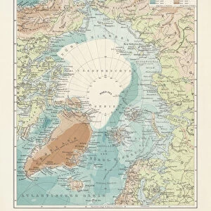
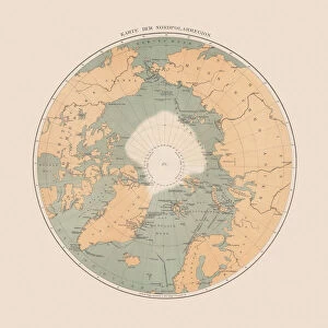
Photo Mug : Historic Map of the Arctic, wood engraving, published in 1882


![]()
Home Decor from Fine Art Storehouse
Historic Map of the Arctic, wood engraving, published in 1882
Historic Map of the Arctic. Wood engraving, published in 1882
Unleash your creativity and transform your space into a visual masterpiece!
Media ID 14756506
© This content is subject to copyright
Alaska America American Asian Canada Circle Globe Greenland Historically Island North America Norway Polar Russia Russian Scandinavia Siberia Square Wood Engraving Asien Erde Geschichte Globus Gravur Gronland Historisch Nordamerika Northwest Passage Norwegen Spitzbergen Stich
Photo Mug
Add a touch of history to your daily routine with our Media Storehouse Photo Mug featuring a stunning wood engraving of a Historic Map of the Arctic. Published in 1882, this exquisite fine art piece transports you back in time, showcasing the intricate details of the Arctic region as it was explored over a century ago. Perfect for tea or coffee, this high-quality mug is a unique and thoughtful gift for history enthusiasts, cartography lovers, or anyone who appreciates the beauty of the past. Embrace the rich history of the Arctic with every sip.
A personalised photo mug blends sentimentality with functionality, making an ideal gift for cherished loved ones, close friends, or valued colleagues. Preview may show both sides of the same mug.
Elevate your coffee or tea experience with our premium white ceramic mug. Its wide, comfortable handle makes drinking easy, and you can rely on it to be both microwave and dishwasher safe. Sold in single units, preview may show both sides of the same mug so you can see how the picture wraps around.
Mug Size is 9.6cm high x 8.1cm diameter (3.8" x 3.2")
These are individually made so all sizes are approximate
FEATURES IN THESE COLLECTIONS
> Fine Art Storehouse
> Map
> Historical Maps
EDITORS COMMENTS
This wood engraving, a historic map of the Arctic, takes us back to 1882 when exploration and discovery were at their peak. The intricate details etched into this print transport us to a time when the vast icy landscapes of the Arctic remained largely uncharted. The map showcases the immense expanse of this polar region, stretching from Greenland in the west to Russia in the east. It highlights significant landmarks such as Alaska, Canada, Scandinavia, Spitzbergen, and even parts of Asia. This comprehensive depiction allows us to appreciate how interconnected these regions are despite their geographical distance. As we gaze upon this ancient cartographic masterpiece, it is impossible not to feel a sense of awe for those intrepid explorers who braved treacherous conditions in search of new trade routes or scientific knowledge. The Northwest Passage is prominently featured on this map—a legendary route that captivated many adventurers throughout history. The square shape adds an element of uniqueness to this wood engraving while emphasizing its historical significance. Each line and curve meticulously carved into the woodcut tells a story waiting to be discovered by curious minds. Whether you are an enthusiast fascinated by history or simply drawn towards antique art forms like engravings and prints, this piece will undoubtedly become a cherished addition to your collection. Let yourself be transported through time as you explore every inch of this remarkable historic map capturing both imagination and curiosity alike.
MADE IN AUSTRALIA
Safe Shipping with 30 Day Money Back Guarantee
FREE PERSONALISATION*
We are proud to offer a range of customisation features including Personalised Captions, Color Filters and Picture Zoom Tools
SECURE PAYMENTS
We happily accept a wide range of payment options so you can pay for the things you need in the way that is most convenient for you
* Options may vary by product and licensing agreement. Zoomed Pictures can be adjusted in the Cart.