Home > North America > United States of America > New York > New York > Maps
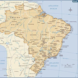
South America map 1875

![]()
Wall Art and Photo Gifts from Fine Art Storehouse
South America map 1875
The Independent Course Comprehensive Geography by James Monteith, A.S. Barnes & Co, New York & Chicago 1875
Unleash your creativity and transform your space into a visual masterpiece!
THEPALMER
Media ID 13612183
© This content is subject to copyright
Argentina Brazil Chile Globe Navigational Equipment Latin America Paper Peru South America Drawing Art Product Latinamerica
FEATURES IN THESE COLLECTIONS
> Fine Art Storehouse
> The Magical World of Illustration
> Palmer Illustrated Collection
> Fine Art Storehouse
> Map
> Historical Maps
> Fine Art Storehouse
> Map
> USA Maps
> Maps and Charts
> Early Maps
> Maps and Charts
> World
> North America
> United States of America
> Maps
> North America
> United States of America
> New York
> New York
> Maps
> South America
> Argentina
> Maps
> South America
> Brazil
> Maps
> South America
> Chile
> Maps
> South America
> Peru
> Maps
EDITORS COMMENTS
This print showcases a vintage map of South America from the year 1875, taken from "The Independent Course Comprehensive Geography" by James Monteith. Published by A. S. Barnes & Co in New York and Chicago, this piece of art takes us on a journey back in time to explore the continent's rich history and geographical features. The intricate details captured in this engraving evoke a sense of wonder and curiosity about the diverse landscapes that make up South America. From the towering Andes Mountains that stretch across Chile, Peru, and Argentina to the vast Amazon rainforest covering Brazil, this map invites us to delve into the natural wonders that define this remarkable region. Printed on aged paper with an etching technique, it exudes an antique charm that transports us to a bygone era when cartography was both scientific and artistic. The precision with which every contour is depicted highlights not only its navigational purpose but also serves as a testament to human fascination with exploration. As we gaze upon this beautifully preserved illustration, we can't help but appreciate how far our understanding of physical geography has come since 1875. Yet at the same time, we are reminded of the timeless beauty and allure that South America continues to hold for adventurers today.
MADE IN AUSTRALIA
Safe Shipping with 30 Day Money Back Guarantee
FREE PERSONALISATION*
We are proud to offer a range of customisation features including Personalised Captions, Color Filters and Picture Zoom Tools
SECURE PAYMENTS
We happily accept a wide range of payment options so you can pay for the things you need in the way that is most convenient for you
* Options may vary by product and licensing agreement. Zoomed Pictures can be adjusted in the Cart.