Photo Mug > Asia > Palestine > Maps
Photo Mug : Map of Palestine 1889


![]()
Home Decor from Fine Art Storehouse
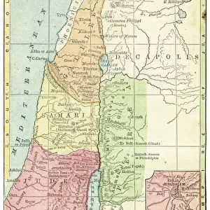
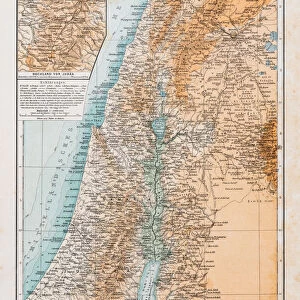
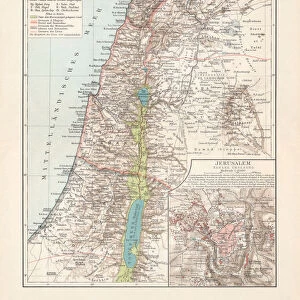
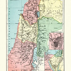
Map of Palestine 1889
Comprehensive Geography by James Monteith - American Book Company 1882, 1889
Unleash your creativity and transform your space into a visual masterpiece!
THEPALMER
Media ID 18357319
Photo Mug
Bring a piece of historical cartography to your morning routine with our Media Storehouse Photo Mug featuring the Map of Palestine 1889 by THEPALMER from the Fine Art Storehouse. This intricately detailed map, taken from Comprehensive Geography by James Monteith published by the American Book Company in 1882 and 1889, is now available in a functional and stylish form. Each mug holds your favorite beverage and showcases this fascinating piece of history, making it an ideal gift for history buffs, geography enthusiasts, or anyone who appreciates the beauty of vintage maps. Embrace the past while enjoying your daily brew.
A personalised photo mug blends sentimentality with functionality, making an ideal gift for cherished loved ones, close friends, or valued colleagues. Preview may show both sides of the same mug.
Elevate your coffee or tea experience with our premium white ceramic mug. Its wide, comfortable handle makes drinking easy, and you can rely on it to be both microwave and dishwasher safe. Sold in single units, preview may show both sides of the same mug so you can see how the picture wraps around.
Mug Size is 9.6cm high x 8.1cm diameter (3.8" x 3.2")
These are individually made so all sizes are approximate
FEATURES IN THESE COLLECTIONS
> Fine Art Storehouse
> Map
> Historical Maps
> Asia
> Palestine
> Related Images
> Maps and Charts
> Related Images
EDITORS COMMENTS
In this print titled "Map of Palestine 1889" we are transported back in time to the late 19th century, immersing ourselves in an era where cartography was both a science and an art form. The image showcases a meticulously detailed map from James Monteith's renowned book "Comprehensive Geography" published by the American Book Company in 1882 and updated in 1889. The map itself is a testament to the immense knowledge and dedication of its creator, as it offers us a comprehensive view of Palestine during that period. Every contour, river, city, and border has been intricately etched onto paper with utmost precision. It serves as a window into history, allowing us to explore the geopolitical landscape of Palestine at that specific point in time. As we gaze upon this remarkable piece from THEPALMER collection at Fine Art Storehouse, our curiosity is piqued by the countless stories waiting to be discovered within these ancient borders. We can almost imagine explorers poring over similar maps during their expeditions or scholars using them as reference material for their academic pursuits. This print not only captures the beauty and historical significance of cartographic art but also invites us to reflect on how our understanding of geography has evolved over time. It reminds us that maps are not merely tools for navigation; they hold within them layers of cultural heritage and human experiences that shape our perception of the world around us.
MADE IN AUSTRALIA
Safe Shipping with 30 Day Money Back Guarantee
FREE PERSONALISATION*
We are proud to offer a range of customisation features including Personalised Captions, Color Filters and Picture Zoom Tools
SECURE PAYMENTS
We happily accept a wide range of payment options so you can pay for the things you need in the way that is most convenient for you
* Options may vary by product and licensing agreement. Zoomed Pictures can be adjusted in the Cart.