Photo Mug > Aerial Photography > Related Images
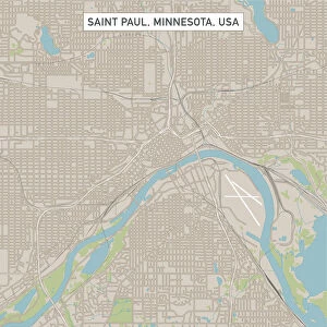
Photo Mug : Minneapolis Minnesota US City Street Map


![]()
Home Decor from Fine Art Storehouse
Minneapolis Minnesota US City Street Map
Vector Illustration of a City Street Map of Minneapolis, Minnesota, USA. Scale 1:60, 000.
All source data is in the public domain.
U.S. Geological Survey, US Topo
Used Layers:
USGS The National Map: National Hydrography Dataset (NHD)
USGS The National Map: National Transportation Dataset (NTD)
Unleash your creativity and transform your space into a visual masterpiece!
Frank Ramspott
Media ID 15215818
© Frank Ramspott, all rights reserved
Aerial View City Map Computer Graphic Directly Above Downtown District Gray Minnesota Mississippi River Road Map Text Digitally Generated Image Green Color Minneapolis White Color
Photo Mug
"Bring a piece of Minneapolis, Minnesota's vibrant urban landscape to your daily routine with our Media Storehouse Photo Mugs. Featuring the intricately detailed "Minneapolis Minnesota US City Street Map" by Frank Ramspott from Fine Art Storehouse, these mugs showcase a vector illustration of the city's iconic streets and landmarks at a scale of 1:60,000. Each mug holds your favorite beverage while providing a captivating view of this beautiful U.S. city. Perfect for both personal use and as a thoughtful gift for the Minneapolis enthusiast in your life. Embrace the essence of Minneapolis with every sip."
A personalised photo mug blends sentimentality with functionality, making an ideal gift for cherished loved ones, close friends, or valued colleagues. Preview may show both sides of the same mug.
Elevate your coffee or tea experience with our premium white ceramic mug. Its wide, comfortable handle makes drinking easy, and you can rely on it to be both microwave and dishwasher safe. Sold in single units, preview may show both sides of the same mug so you can see how the picture wraps around.
Mug Size is 9.6cm high x 8.1cm diameter (3.8" x 3.2")
These are individually made so all sizes are approximate
FEATURES IN THESE COLLECTIONS
> Fine Art Storehouse
> Map
> Street Maps
> Fine Art Storehouse
> Map
> USA Maps
> Aerial Photography
> Related Images
> Animals
> Insects
> Hemiptera
> Green Scale
> Arts
> Contemporary art
> Digital artwork
> Street art
> Arts
> Landscape paintings
> Waterfall and river artworks
> River artworks
> Arts
> Portraits
> Pop art gallery
> Street art portraits
> Arts
> Street art graffiti
> Digital art
> Digital paintings
> Arts
> Street art graffiti
> Digital art
> Vector illustrations
> Maps and Charts
> Geological Map
> Maps and Charts
> Related Images
> North America
> United States of America
> Lakes
> Related Images
EDITORS COMMENTS
This print showcases a meticulously detailed vector illustration of the vibrant city street map of Minneapolis, Minnesota, USA. With a scale of 1:60,000, every intricate detail is brought to life in this visually stunning artwork. The source data used for this masterpiece is all in the public domain and includes USGS The National Map: National Hydrography Dataset (NHD) and USGS The National Map: National Transportation Dataset (NTD). From the iconic Mississippi River winding through the city to the bustling downtown district and serene lakeside areas, this print captures the essence of Minneapolis' diverse geography. Every road and street is intricately mapped out, providing an accurate representation of this dynamic urban landscape. The design itself is digitally generated with no people present in order to focus solely on showcasing the beauty and complexity of Minneapolis' streetscape. Aerial view perspective allows viewers to appreciate every element from directly above. The color palette chosen for this artwork includes shades of gray, blue, white, and green which perfectly complement each other while highlighting different features on the map. This fine art print by Frank Ramspott truly encapsulates both cartography expertise and artistic vision. It serves as a testament to how technology can transform raw data into a visually striking piece that celebrates physical geography in all its glory.
MADE IN AUSTRALIA
Safe Shipping with 30 Day Money Back Guarantee
FREE PERSONALISATION*
We are proud to offer a range of customisation features including Personalised Captions, Color Filters and Picture Zoom Tools
SECURE PAYMENTS
We happily accept a wide range of payment options so you can pay for the things you need in the way that is most convenient for you
* Options may vary by product and licensing agreement. Zoomed Pictures can be adjusted in the Cart.