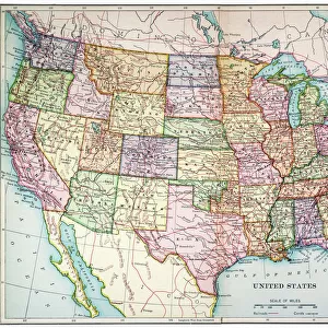
Photo Mug > North America > Mexico > Maps
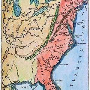
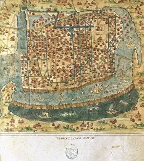
Photo Mug : MAP OF COLONIAL AMERICA. Delisles map of colonial America, 1718, showing the Mississippi


![]()
Home Decor from Granger
MAP OF COLONIAL AMERICA. Delisles map of colonial America, 1718, showing the Mississippi
MAP OF COLONIAL AMERICA.
Delisles map of colonial America, 1718, showing the Mississippi valley in strikingly accurate detail and the first map to use Texas as a place-name
Granger holds millions of images spanning more than 25,000 years of world history, from before the Stone Age to the dawn of the Space Age
Media ID 12320971
1718 Colony Guillaume Gulf Of Mexico Louisiana Mississippi River United States Valley Delisle Southeast
Photo Mug
"Bring history to your morning routine with our Media Storehouse Photo Mug featuring the intricately detailed Delisles Map of Colonial America from 1718. This vintage map, sourced from Granger Art on Demand, is the first to use the name "Texas" and show the Mississippi Valley in accurate detail. Each sip from this high-quality mug is a journey back in time, making it a unique and thoughtful gift for history enthusiasts or anyone who appreciates the beauty of antique maps."
A personalised photo mug blends sentimentality with functionality, making an ideal gift for cherished loved ones, close friends, or valued colleagues. Preview may show both sides of the same mug.
Elevate your coffee or tea experience with our premium white ceramic mug. Its wide, comfortable handle makes drinking easy, and you can rely on it to be both microwave and dishwasher safe. Sold in single units, preview may show both sides of the same mug so you can see how the picture wraps around.
Mug Size is 8.1cm high x 9.6cm diameter (3.2" x 3.8")
These are individually made so all sizes are approximate
FEATURES IN THESE COLLECTIONS
> Granger Art on Demand
> Maps
> Historic
> Colonial America illustrations
> Colonial America
> Maps and Charts
> Early Maps
> Maps and Charts
> Related Images
> North America
> Mexico
> Maps
> North America
> Mexico
> Related Images
EDITORS COMMENTS
This print showcases Delisles map of colonial America from 1718, providing a fascinating glimpse into the early days of American history. The intricate details and accuracy with which the Mississippi valley is depicted are truly striking, making this map an invaluable resource for understanding the geographical landscape of that time. What sets this particular map apart is its distinction as the first to use Texas as a place-name. This groundbreaking inclusion highlights the evolving nature of cartography during this period and sheds light on how territories were being defined and named in colonial America. The image transports us back to a time when French influence was prominent in North America, as evidenced by Guillaume Delisle's involvement in creating this masterpiece. As we study the map, we can envision explorers traversing through Louisiana and navigating along the mighty Mississippi River. The Gulf of Mexico looms large on this map, reminding us of its significance as a gateway for trade and exploration during those early years. It serves as a reminder that even before becoming independent states, these colonies were already interconnected with each other and with foreign powers. Overall, this print offers not only historical value but also aesthetic appeal. It invites us to delve into our past and marvel at how far we have come since then.
MADE IN AUSTRALIA
Safe Shipping with 30 Day Money Back Guarantee
FREE PERSONALISATION*
We are proud to offer a range of customisation features including Personalised Captions, Color Filters and Picture Zoom Tools
SECURE PAYMENTS
We happily accept a wide range of payment options so you can pay for the things you need in the way that is most convenient for you
* Options may vary by product and licensing agreement. Zoomed Pictures can be adjusted in the Cart.