Photo Mug > Arts > Landscape paintings > Waterfall and river artworks > River artworks
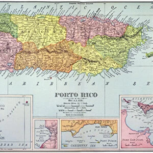
Photo Mug : MAP: PUERTO RICO, 1900. Map of Puerto Rico printed in the United States, c1900


![]()
Home Decor from Granger
MAP: PUERTO RICO, 1900. Map of Puerto Rico printed in the United States, c1900
Granger holds millions of images spanning more than 25,000 years of world history, from before the Stone Age to the dawn of the Space Age
Media ID 6622165
1900 Carribean Latin America Latin American Puerto Rican Puerto Rico
Photo Mug
"Add a touch of history to your daily routine with our Media Storehouse Photo Mug featuring the vintage map of Puerto Rico from 1900. Printed in the United States, this antique map, sourced from The Granger Collection at Granger Art on Demand, showcases intricate details of the island's geography from a bygone era. Each mug is expertly crafted with high-quality ceramic and vibrant, fade-resistant image transfer technology, ensuring your map mug not only looks great but is durable enough for everyday use. Perfect for history enthusiasts, travelers, or anyone who appreciates the beauty of old maps, this unique mug is sure to make your coffee or tea breaks more enjoyable."
A personalised photo mug blends sentimentality with functionality, making an ideal gift for cherished loved ones, close friends, or valued colleagues. Preview may show both sides of the same mug.
Elevate your coffee or tea experience with our premium white ceramic mug. Its wide, comfortable handle makes drinking easy, and you can rely on it to be both microwave and dishwasher safe. Sold in single units, preview may show both sides of the same mug so you can see how the picture wraps around.
Mug Size is 8.1cm high x 9.6cm diameter (3.2" x 3.8")
These are individually made so all sizes are approximate
FEATURES IN THESE COLLECTIONS
> Granger Art on Demand
> Maps
> Arts
> Landscape paintings
> Waterfall and river artworks
> River artworks
> Maps and Charts
> Early Maps
> Maps and Charts
> Related Images
> North America
> Puerto Rico
> Maps
> North America
> Puerto Rico
> Related Images
EDITORS COMMENTS
This print titled "MAP: PUERTO RICO, 1900" takes us back in time to the early 20th century, offering a glimpse into the intricate cartography of Puerto Rico. Created and printed in the United States around 1900, this map showcases the rich history and cultural significance of this beautiful Caribbean island. The map itself is a true work of art, meticulously detailing every river, town, and landmark that graces Puerto Rico's landscape. Its vibrant colors and delicate lines invite viewers to explore its depths and unravel its hidden stories. The careful craftsmanship behind this piece reflects not only the skill of its creators but also their deep appreciation for geography. As we delve into this snapshot from history, we are transported to an era when Puerto Rico was still under American control. It serves as a reminder of the complex relationship between these two nations during that time period. This map stands as a testament to both Puerto Rican identity and American influence on Latin America. Whether you have ties to Puerto Rico or simply appreciate historical artifacts like maps, this print offers an opportunity for reflection and exploration. It allows us to connect with our past while appreciating the beauty found within cartographic representations. So take a moment to immerse yourself in "MAP: PUERTO RICO, 1900" let it spark your curiosity about this enchanting island's history, culture, and natural wonders
MADE IN AUSTRALIA
Safe Shipping with 30 Day Money Back Guarantee
FREE PERSONALISATION*
We are proud to offer a range of customisation features including Personalised Captions, Color Filters and Picture Zoom Tools
SECURE PAYMENTS
We happily accept a wide range of payment options so you can pay for the things you need in the way that is most convenient for you
* Options may vary by product and licensing agreement. Zoomed Pictures can be adjusted in the Cart.