Photo Mug > Maps and Charts > Related Images
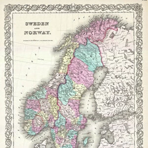
Photo Mug : Map Magni ducatus Lithuaniae divisa tam palatinatus quam


![]()
Home Decor from Liszt Collection
Map Magni ducatus Lithuaniae divisa tam palatinatus quam
Map, Magni ducatus Lithuaniae divisa tam in palatinatus quam in subiacentes castellanias authore per R. & J. Ottens Amst, Reinier Ottens (1698-1750), Josua Ottens (1704-1765), Copperplate print
Liszt Collection of nineteenth-century engravings and images to browse and enjoy
Media ID 19585001
© Artokoloro
1698 1750 1704 1765 Copperplate Print Reinier Ottens
Photo Mug
Add a touch of history to your daily routine with our Media Storehouse Photo Mugs. Featuring the intricately detailed Map of the Grand Duchy of Lithuania, divided into palatinates and subordinate castellanies, from the renowned Liszt Collection. This exquisite copperplate print, created by R. & J. Ottens in Amsterdam, showcases the rich historical significance of this region. Each mug holds your favorite beverage while allowing you to savor the beauty of the past with every sip.
A personalised photo mug blends sentimentality with functionality, making an ideal gift for cherished loved ones, close friends, or valued colleagues. Preview may show both sides of the same mug.
Elevate your coffee or tea experience with our premium white ceramic mug. Its wide, comfortable handle makes drinking easy, and you can rely on it to be both microwave and dishwasher safe. Sold in single units, preview may show both sides of the same mug so you can see how the picture wraps around.
Mug Size is 8.1cm high x 9.6cm diameter (3.2" x 3.8")
These are individually made so all sizes are approximate
EDITORS COMMENTS
This print showcases a remarkable map titled "Map Magni ducatus Lithuaniae divisa tam palatinatus quam". Created by the talented duo Reinier and Josua Ottens in Amsterdam, this copperplate print is a true masterpiece. The intricate details and precision of this map are truly awe-inspiring. The map beautifully depicts the grand duchy of Lithuania, divided into both palatinates and subjugated castellanies. Its rich colors bring to life the vast territories that once belonged to this historic region. Every stroke on this copperplate print tells a story, revealing the immense knowledge and skill possessed by its creators. Reinier Ottens (1698-1750) and Josua Ottens (1704-1765) have left an indelible mark on cartography with their exceptional craftsmanship. This print allows us to appreciate their dedication to accuracy and artistry even centuries later. As we gaze upon this magnificent piece, we can't help but be transported back in time, imagining the explorers who relied on maps like these for navigation or historians who sought insights into past civilizations. It serves as a testament to human curiosity and our constant quest for knowledge about our world's history. Whether you are an avid collector or simply fascinated by historical artifacts, this print is sure to captivate your imagination while adding a touch of elegance to any space it graces.
MADE IN AUSTRALIA
Safe Shipping with 30 Day Money Back Guarantee
FREE PERSONALISATION*
We are proud to offer a range of customisation features including Personalised Captions, Color Filters and Picture Zoom Tools
SECURE PAYMENTS
We happily accept a wide range of payment options so you can pay for the things you need in the way that is most convenient for you
* Options may vary by product and licensing agreement. Zoomed Pictures can be adjusted in the Cart.