Photographic Print > Maps and Charts > Related Images
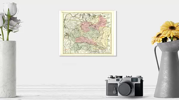
Photographic Print : Map Magni ducatus Lithuaniae divisa tam palatinatus quam


![]()
Photo Prints from Liszt Collection
Map Magni ducatus Lithuaniae divisa tam palatinatus quam
Map, Magni ducatus Lithuaniae divisa tam in palatinatus quam in subiacentes castellanias authore per R. & J. Ottens Amst, Reinier Ottens (1698-1750), Josua Ottens (1704-1765), Copperplate print
Liszt Collection of nineteenth-century engravings and images to browse and enjoy
Media ID 19585001
© Artokoloro
1698 1750 1704 1765 Copperplate Print Reinier Ottens
10"x8" (25x20cm) Photo Print
Discover the rich history of Lithuania with our exquisite Media Storehouse Photographic Print of the Map "Magni Ducatus Lithuaniae divisa tam palatinatus quam in subiacentes castellanias." This stunning copperplate print, hailing from the renowned Liszt Collection, offers a captivating glimpse into the political landscape of Lithuania during the 17th century. The intricate details of the map, produced by R. & J. Ottens in Amsterdam, reveal the palatinates and castellanies that once shaped this historic region. Bring a piece of European history into your home or office with this beautiful, museum-quality photographic print.
Ideal for framing, Australian made Photo Prints are produced on high-quality 270 gsm lustre photo paper which has a subtle shimmer adding a touch of elegance, designed to enhance their visual appeal.
Our Photo Prints are in a large range of sizes and are printed on Archival Quality Paper for excellent colour reproduction and longevity. They are ideal for framing (our Framed Prints use these) at a reasonable cost. Alternatives include cheaper Poster Prints and higher quality Fine Art Paper, the choice of which is largely dependant on your budget.
Estimated Product Size is 25.4cm x 20.3cm (10" x 8")
These are individually made so all sizes are approximate
Artwork printed orientated as per the preview above, with landscape (horizontal) orientation to match the source image.
EDITORS COMMENTS
This print showcases a remarkable map titled "Map Magni ducatus Lithuaniae divisa tam palatinatus quam". Created by the talented duo Reinier and Josua Ottens in Amsterdam, this copperplate print is a true masterpiece. The intricate details and precision of this map are truly awe-inspiring. The map beautifully depicts the grand duchy of Lithuania, divided into both palatinates and subjugated castellanies. Its rich colors bring to life the vast territories that once belonged to this historic region. Every stroke on this copperplate print tells a story, revealing the immense knowledge and skill possessed by its creators. Reinier Ottens (1698-1750) and Josua Ottens (1704-1765) have left an indelible mark on cartography with their exceptional craftsmanship. This print allows us to appreciate their dedication to accuracy and artistry even centuries later. As we gaze upon this magnificent piece, we can't help but be transported back in time, imagining the explorers who relied on maps like these for navigation or historians who sought insights into past civilizations. It serves as a testament to human curiosity and our constant quest for knowledge about our world's history. Whether you are an avid collector or simply fascinated by historical artifacts, this print is sure to captivate your imagination while adding a touch of elegance to any space it graces.
MADE IN AUSTRALIA
Safe Shipping with 30 Day Money Back Guarantee
FREE PERSONALISATION*
We are proud to offer a range of customisation features including Personalised Captions, Color Filters and Picture Zoom Tools
SECURE PAYMENTS
We happily accept a wide range of payment options so you can pay for the things you need in the way that is most convenient for you
* Options may vary by product and licensing agreement. Zoomed Pictures can be adjusted in the Cart.