Photo Mug > Animals > Mammals > Cats (Domestic) > Scottish Fold
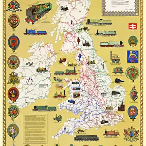
Photo Mug : Pictorial History Railway Map of Britain


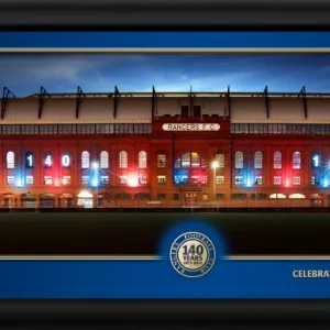
![]()
Home Decor from MapSeeker
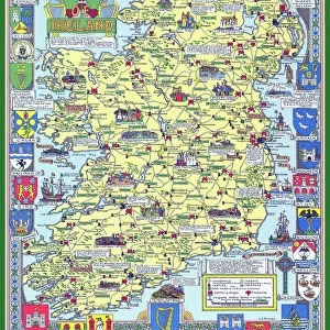
Pictorial History Railway Map of Britain
This is a wonderful large format pictorial map illustrating the history of the Railways of Britain up to its original publication date of 1974. Drawn by Laurence Richardson and last published in 1974 by Collins Bartholomew as a fold up map. Now re-digitized and re-published by Mapseeker in association with the Collins Bartholomew Archive, the map covers all of England, Wales, Scotland and Ireland with various historical events, progress, iconic steam locomotives, heritage railways illustrated pictorially in the form of eye catching vignettes. The map is surrounded by the crests of many of the Railway Companies that were founded over time until they were consumed under the Amalgamation of 1923
Welcome to the Mapseeker Image library and enter an historic gateway to one of the largest on-line collections of Historic Maps, Nostalgic Views, Vista's and Panorama's from a World gone by.
Media ID 20347943
© reserved
Photo Mug
Introducing the Media Storehouse Photo Mug featuring a captivating image of the "Pictorial History Railway Map of Britain" from MapSeeker. This mug is not just a beverage holder; it's a journey through time. The intricately detailed map illustrates the rich history of the railways in Britain up to 1974. Each sip from this mug brings you closer to the fascinating stories of the past, making your coffee or tea break an adventure. Perfect for railway enthusiasts, history buffs, or anyone who appreciates the beauty of vintage maps, this mug is a must-have addition to your collection. Embrace the nostalgia and relive the journey with every use.
A personalised photo mug blends sentimentality with functionality, making an ideal gift for cherished loved ones, close friends, or valued colleagues. Preview may show both sides of the same mug.
Elevate your coffee or tea experience with our premium white ceramic mug. Its wide, comfortable handle makes drinking easy, and you can rely on it to be both microwave and dishwasher safe. Sold in single units, preview may show both sides of the same mug so you can see how the picture wraps around.
Mug Size is 9.6cm high x 8.1cm diameter (3.8" x 3.2")
These are individually made so all sizes are approximate
FEATURES IN THESE COLLECTIONS
> MapSeeker
> Pictorial Maps and Pictorial History
> Pictorial History Maps PORTFOLIO
> Animals
> Mammals
> Cats (Domestic)
> Scottish Fold
> Europe
> Republic of Ireland
> Maps
> Europe
> United Kingdom
> England
> Maps
> Europe
> United Kingdom
> England
> Railways
> Europe
> United Kingdom
> Scotland
> Maps
> Europe
> United Kingdom
> Scotland
> Posters
> Europe
> United Kingdom
> Scotland
> Railways
> Europe
> United Kingdom
> Scotland
> Related Images
> Europe
> United Kingdom
> Wales
> Maps
> Europe
> United Kingdom
> Wales
> Posters
EDITORS COMMENTS
This print showcases the remarkable "Pictorial History Railway Map of Britain". Originally crafted by Laurence Richardson and last published in 1974, this large format map has been meticulously re-digitized and re-published by Mapseeker in collaboration with the esteemed Collins Bartholomew Archive. Spanning across England, Wales, Scotland, and Ireland, this exquisite map offers a visual journey through the rich history of British railways up until its publication date. The map is adorned with an array of eye-catching vignettes that vividly illustrate various historical events, milestones in progress, as well as iconic steam locomotives and heritage railways. Surrounding these captivating visuals are the crests of numerous railway companies that once flourished before being amalgamated under the historic Amalgamation Act of 1923. With its intricate details and nostalgic charm, this print serves as a testament to Britain's enduring love affair with trains. It allows viewers to immerse themselves in a bygone era when railways were at their zenith – connecting towns and cities while shaping the nation's industrial landscape. Whether you are an avid train enthusiast or simply appreciate British history, this extraordinary pictorial map is sure to captivate your imagination. Let it transport you back in time as you marvel at the evolution of one of Britain's most cherished modes of transportation.
MADE IN AUSTRALIA
Safe Shipping with 30 Day Money Back Guarantee
FREE PERSONALISATION*
We are proud to offer a range of customisation features including Personalised Captions, Color Filters and Picture Zoom Tools
SECURE PAYMENTS
We happily accept a wide range of payment options so you can pay for the things you need in the way that is most convenient for you
* Options may vary by product and licensing agreement. Zoomed Pictures can be adjusted in the Cart.