Home > Europe > United Kingdom > Scotland > Maps
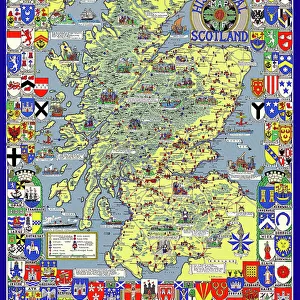
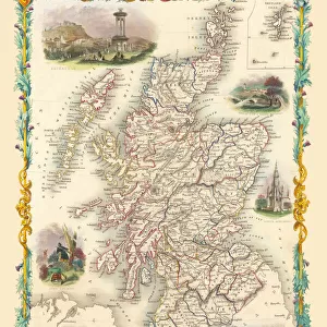
The Historic Map of Scotland "Scotland of Old"

![]()
Wall Art and Photo Gifts from MapSeeker
The Historic Map of Scotland "Scotland of Old"
Now republished at its original full size, the Scotland of Old Map, also known as the Bartholomew Clan Map of Scotland, features " The Lands", " The Arms", " The Crests". The central map delineates the clan territories and is framed by the serried array of a hundred and seventy heraldic shields along with their crests and mottoes. The whole piece was designed by the late Don Pottinger who painted it as a single artwork
Welcome to the Mapseeker Image library and enter an historic gateway to one of the largest on-line collections of Historic Maps, Nostalgic Views, Vista's and Panorama's from a World gone by.
Media ID 20348140
Historic Map Old Map Of Scotland Old Scotland Map Old Scottish Map Scotland Scotland Map Scottish Map
FEATURES IN THESE COLLECTIONS
> Europe
> United Kingdom
> Scotland
> Maps
> Maps and Charts
> Popular Maps
> Maps and Charts
> Related Images
> MapSeeker
> Maps from the British Isles
> Scotland and Counties PORTFOLIO
EDITORS COMMENTS
Step back in time with "The Historic Map of Scotland: Scotland of Old". This exquisite print, now republished at its original full size, takes you on a journey through the rich history and heritage of Scotland. Known as the Bartholomew Clan Map of Scotland, this masterpiece showcases "The Lands" "The Arms" and "The Crests" of each clan. Designed by the late Don Pottinger as a single artwork, this map is a true labor of love. The central map meticulously delineates the territories belonging to each clan, providing a fascinating glimpse into their ancestral lands. Surrounding it are an impressive array of one hundred and seventy heraldic shields adorned with crests and mottoes, creating an awe-inspiring sight. As you explore this historic map, you can't help but be captivated by its intricate details and artistic brilliance. Every brushstroke tells a story, every crest represents centuries-old traditions passed down through generations. It's not just a map; it's a testament to the enduring spirit of Scottish clans. Whether you're tracing your own family roots or simply fascinated by Scottish history, this old map offers an unparalleled window into the past. With its timeless charm and undeniable beauty, it serves as both an educational resource and a stunning piece for display. Don Pottinger's dedication to preserving Scotland's heritage shines through in every inch of this remarkable artwork. So immerse yourself in the world of ancient clans and tartans with "The Historic Map of Scotland:
MADE IN AUSTRALIA
Safe Shipping with 30 Day Money Back Guarantee
FREE PERSONALISATION*
We are proud to offer a range of customisation features including Personalised Captions, Color Filters and Picture Zoom Tools
SECURE PAYMENTS
We happily accept a wide range of payment options so you can pay for the things you need in the way that is most convenient for you
* Options may vary by product and licensing agreement. Zoomed Pictures can be adjusted in the Cart.