Photo Mug : Cover design, Imperial Airways map, 1933


![]()
Home Decor from Mary Evans Picture Library
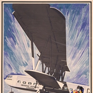
Cover design, Imperial Airways map, 1933
Cover design, Imperial Airways map of air routes, 1933, price two shillings.
1933
Mary Evans Picture Library makes available wonderful images created for people to enjoy over the centuries
Media ID 14360697
© Onslows Auctioneers / Mary Evans Picture Library
1933 Airways Basle Brussels Cologne Koln Price Routes Shillings Stylised Zurich Deco
Photo Mug
Step back in time with our Media Storehouse Photo Mug, featuring an iconic cover design from the past. This vintage Imperial Airways map, originally published in 1933, showcases the fascinating history of air travel with intricate detail. Each mug is expertly printed with high-quality images from the Mary Evans Picture Library, ensuring a stunning and long-lasting display of this historical treasure. Perfect for aviation enthusiasts, history buffs, or anyone who appreciates the beauty of classic design, our Photo Mug makes a unique and thoughtful gift. Embrace the nostalgia and enjoy your favorite beverage in style.
A personalised photo mug blends sentimentality with functionality, making an ideal gift for cherished loved ones, close friends, or valued colleagues. Preview may show both sides of the same mug.
Elevate your coffee or tea experience with our premium white ceramic mug. Its wide, comfortable handle makes drinking easy, and you can rely on it to be both microwave and dishwasher safe. Sold in single units, preview may show both sides of the same mug so you can see how the picture wraps around.
Mug Size is 9.6cm high x 8.1cm diameter (3.8" x 3.2")
These are individually made so all sizes are approximate
EDITORS COMMENTS
this vintage print showcases the cover design of an Imperial Airways map from 1933. The design is a stunning example of the Art Deco style, with its harmonious blend of geometric shapes, bold lines, and a palette of soothing grey, blue, and white tones. The central focus of the cover is a stylized representation of an aeroplane soaring through the sky, its wings outstretched and propellers in motion, symbolizing the spirit of adventure and progress embodied by air travel during this era. The map itself is a testament to the extensive reach of Imperial Airways' passenger services, covering various destinations across Europe. London, the United Kingdom's capital city, is prominently featured at the heart of the map, with key European cities such as Paris in France, Basle and Zurich in Switzerland, Brussels in Belgium, and Cologne (Koln) in Germany, all connected by intricate, winding lines that represent the air routes. The map is priced at two shillings, reflecting the affordability and accessibility of air travel during this period. This piece of history transports us back to an age of glamour and excitement, when the world seemed smaller and the possibilities for exploration seemed endless. Imperial Airways was a British airline that operated from 1924 to 1974, and this map serves as a fascinating glimpse into the company's rich history and the evolution of air travel during the early 20th century. This print is an essential addition to any collection focusing on aviation history, graphic design, or vintage travel memorabilia. This image is available for licensing through Onslows Auctioneers and Mary Evans Picture Library.
MADE IN AUSTRALIA
Safe Shipping with 30 Day Money Back Guarantee
FREE PERSONALISATION*
We are proud to offer a range of customisation features including Personalised Captions, Color Filters and Picture Zoom Tools
SECURE PAYMENTS
We happily accept a wide range of payment options so you can pay for the things you need in the way that is most convenient for you
* Options may vary by product and licensing agreement. Zoomed Pictures can be adjusted in the Cart.