Photo Mug > Historic > Ancient civilizations > Ancient Greece > Greek history
Photo Mug : Map / Europe / Balkans C1850


![]()
Home Decor from Mary Evans Picture Library
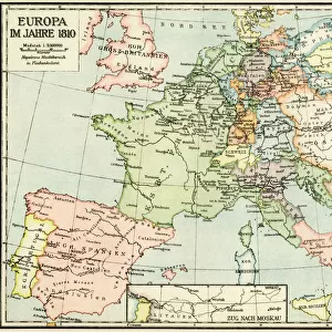
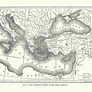
Map / Europe / Balkans C1850
The Turkish-occupied territories in Europe, comprising all the Balkans apart from Greece
Mary Evans Picture Library makes available wonderful images created for people to enjoy over the centuries
Media ID 4342665
© Mary Evans Picture Library 2015 - https://copyrighthub.org/s0/hub1/creation/maryevans/MaryEvansPictureID/10046914
1850 Balkans C1850 Comprising Maps Occupied Territories
Photo Mug
"Add a touch of history to your morning routine with our Media Storehouse Photo Mugs. Featuring an intriguing image of "Map / Europe / Balkans C1850" by Rights Managed from Mary Evans Prints Online, this mug showcases the Turkish-occupied territories in Europe during the 19th century. Each mug is expertly printed with high-quality, vibrant colors, ensuring your favorite images remain as stunning as the day they were taken. Make every sip a journey through time and add this unique mug to your collection today."
A personalised photo mug blends sentimentality with functionality, making an ideal gift for cherished loved ones, close friends, or valued colleagues. Preview may show both sides of the same mug.
Elevate your coffee or tea experience with our premium white ceramic mug. Its wide, comfortable handle makes drinking easy, and you can rely on it to be both microwave and dishwasher safe. Sold in single units, preview may show both sides of the same mug so you can see how the picture wraps around.
Mug Size is 9.6cm high x 8.1cm diameter (3.8" x 3.2")
These are individually made so all sizes are approximate
FEATURES IN THESE COLLECTIONS
> Asia
> Turkey
> Related Images
> Europe
> Greece
> Related Images
> Europe
> Related Images
> Historic
> Ancient civilizations
> Ancient Greece
> Greek history
> Maps and Charts
> Early Maps
> Maps and Charts
> Related Images
EDITORS COMMENTS
This vintage map print from Mary Evans Prints Online showcases Europe in the year 1850, specifically focusing on the Balkans region which was predominantly under Turkish occupation at that time. The intricate details of this historical map provide a glimpse into the complex political landscape of the era, with all Balkan territories except Greece being controlled by the Ottoman Empire.
The borders and boundaries depicted on this map offer a visual representation of the power dynamics and territorial divisions that characterized Europe during this period. It serves as a reminder of the turbulent history of the Balkans, marked by centuries of conflict and conquest.
As we study this map, we are transported back in time to an era when empires vied for control over strategic regions like the Balkans. The names of cities and regions evoke images of ancient civilizations and long-forgotten battles that shaped the course of European history.
This print is not just a geographical representation but a window into a world where empires rose and fell, leaving behind legacies that continue to influence modern geopolitics. It is a testament to the enduring importance of understanding our past in order to navigate our present and future with wisdom and insight.
MADE IN AUSTRALIA
Safe Shipping with 30 Day Money Back Guarantee
FREE PERSONALISATION*
We are proud to offer a range of customisation features including Personalised Captions, Color Filters and Picture Zoom Tools
SECURE PAYMENTS
We happily accept a wide range of payment options so you can pay for the things you need in the way that is most convenient for you
* Options may vary by product and licensing agreement. Zoomed Pictures can be adjusted in the Cart.