Photo Mug > Europe > Republic of Ireland > Maps
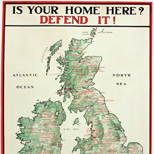
Photo Mug : MAPS / BRITAIN / 1763


![]()
Home Decor from Mary Evans Picture Library
MAPS / BRITAIN / 1763
An accurate map of Great Britain and Ireland from the best authorities
Mary Evans Picture Library makes available wonderful images created for people to enjoy over the centuries
Media ID 620765
© Mary Evans Picture Library 2015 - https://copyrighthub.org/s0/hub1/creation/maryevans/MaryEvansPictureID/10074331
1763 Accurate Authorities Best Maps
Photo Mug
Discover the perfect blend of history and personalization with our Media Storehouse Photo Mugs featuring the captivating "MAPS / BRITAIN / 1763" image from Mary Evans Picture Library. This exquisite map, sourced from Mary Evans Prints Online, offers an accurate representation of Great Britain and Ireland as it appeared in 1763, making it a fascinating conversation starter. Our high-quality mugs not only showcase this historical detail but are also designed to keep your beverages warm and cozy. Whether it's for yourself or as a thoughtful gift, this Photo Mug is a must-have for history enthusiasts, map collectors, or anyone who appreciates the beauty of vintage cartography.
A personalised photo mug blends sentimentality with functionality, making an ideal gift for cherished loved ones, close friends, or valued colleagues. Preview may show both sides of the same mug.
Elevate your coffee or tea experience with our premium white ceramic mug. Its wide, comfortable handle makes drinking easy, and you can rely on it to be both microwave and dishwasher safe. Sold in single units, preview may show both sides of the same mug so you can see how the picture wraps around.
Mug Size is 9.6cm high x 8.1cm diameter (3.8" x 3.2")
These are individually made so all sizes are approximate
FEATURES IN THESE COLLECTIONS
> Europe
> Republic of Ireland
> Maps
> Maps and Charts
> Early Maps
> Maps and Charts
> Related Images
EDITORS COMMENTS
This stunning print captures a piece of history with an accurate map of Great Britain and Ireland from 1763. Created by the best authorities of the time, this detailed map provides a glimpse into the geographical landscape of Britain and Ireland during this significant period in history.
The intricate details on the map showcase the various regions, cities, and landmarks that were present over two centuries ago. From London to Dublin, Edinburgh to Cardiff, each location is meticulously labeled, giving viewers a sense of how these countries were structured in the past.
As we study this historical map, we can appreciate the craftsmanship and expertise that went into creating such an accurate representation of Great Britain and Ireland. It serves as a reminder of how far cartography has come since then while also highlighting the importance of preserving these pieces of our past.
Whether you're a history buff or simply fascinated by maps, this print from Mary Evans Picture Library is sure to captivate your imagination. Step back in time and explore Great Britain and Ireland as it was seen through the eyes of experts in 1763 - a true treasure for any lover of historical artifacts.
MADE IN AUSTRALIA
Safe Shipping with 30 Day Money Back Guarantee
FREE PERSONALISATION*
We are proud to offer a range of customisation features including Personalised Captions, Color Filters and Picture Zoom Tools
SECURE PAYMENTS
We happily accept a wide range of payment options so you can pay for the things you need in the way that is most convenient for you
* Options may vary by product and licensing agreement. Zoomed Pictures can be adjusted in the Cart.